
Qaidam Basin Semi-Desert
The ecoregion’s land area is provided in units of 1,000 hectares. The conservation target is the Global Safety Net (GSN1) area for the given ecoregion. The protection level indicates the percentage of the GSN goal that is currently protected on a scale of 0-10. N/A means data is not available at this time.
Bioregion: Greater Tibetan Plateau Alpine Meadows & Shrublands (PA40)
Realm: Eastern Eurasia
Ecoregion Size (1000 ha):
19,247
Ecoregion ID:
835
Conservation Target:
81%
Protection Level:
0
States: China
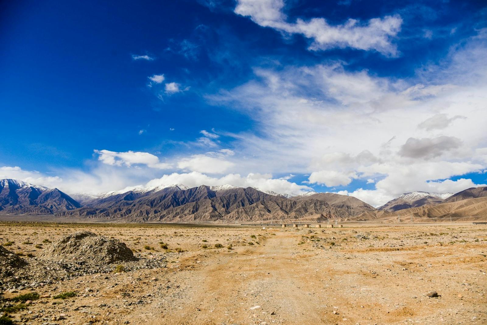
The Qaidam Basin Semi-desert ecoregion occupies a tectonic depression, or graben, that slumps between the Tibet Plateau, the Altun mountain range, and the western part of the rapidly uplifting Qilian mountain range. Bottomlands, still at 2,700 m elevation, hold sediments eroded from the surrounding mountains. Saline lakes and salt deposits occur here as well because water that flows into the Qaidam Basin can only evaporate, concentrating solutes as it does so.
Until recently, the Qaidam basin is mostly uninhabited and has a severe continental climate made all the more harsh by persistent seasonal winds in winter and sandstorms in spring. The interior of the Qaidam basin is very dry – its western part receives only 15 mm mean annual precipitation. Surrounding mountain ranges draw thunderstorms in the summer, making the periphery of the Qaidam Basin a little less arid.
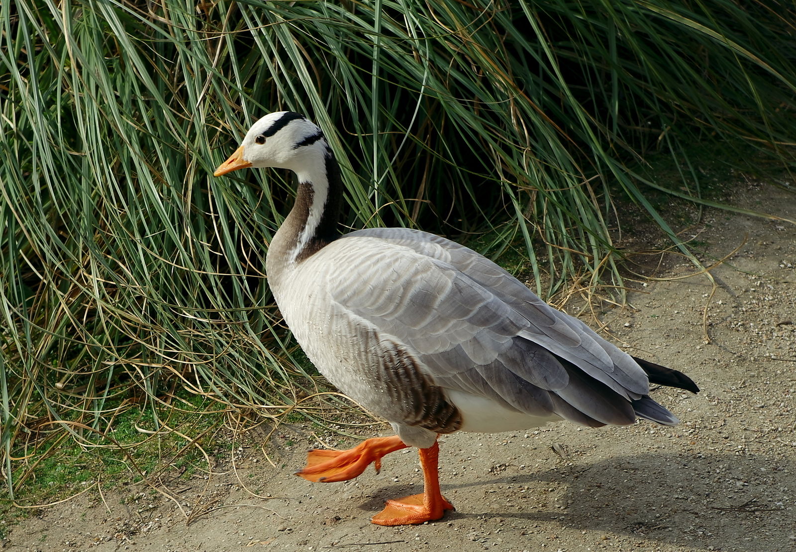
The flagship species of the Qaidam Basin Semi-Desert ecoregion is the bar-headed goose. Image credit: Dinkum, Creative Commons
Hillsides and alluvial fans, with gravelly, well-drained soils, support sparse desert vegetation. Shrubs are scattered in canyons where river channels wend down from the mountains and ground water is close to the surface. The wetter, eastern part of the Qaidam Basin is a little less barren, but the western lowlands can be almost entirely devoid of vegetation.
Among the more apparent plant species is black saxaul, a robust, cold and salt-tolerant plant of the amaranth family that can grow as a shrub or small tree. Where it grows, this species is an important component of the ecosystem because it is the only plant large enough to produce fuel or cast shade, and it functions to stabilize soils that might otherwise blow into dunes. Another species native to Qaidam Basin is the ‘tumbleweed,’ Kali collinum, which was introduced to North America in the 19th century to become an invasive icon of the American West.
Oases watered by snowmelt from surrounding mountains support woodlands of desert popular as the potential vegetation. Practically all such well-watered habitats, however, have been converted to agriculture. Until recently, higher elevations at the perimeter of this ecoregion supported wild ungulates, including black-tailed gazelle, blue sheep, wild yak, Asiatic wild ass, and argali together with predators such as brown bear, wolf, and lynx. During the 20th century, however, populations of all of these mammal species diminished and they are now restricted to surrounding upland areas outside the ecoregion.
_resized.jpg)
European brown bear. Image credit: Francis C. Franklin, Creative Commons
Keluke Lake-Tuosu Lake Nature Reserve in the eastern part of the Qaidam Basin includes reed beds that support waterfowl, including ducks and bar-headed goose. The easternmost part of the Altun Shan National Nature Reserve extends into the Qaidam Basin, but it is doubtful that this part contains wildlife of conservation significance. In fact, there is a lack of recent information about the wildlife of this ecoregion. Although the Qaidam Basin is not well surveyed for reptiles, one burrow-dwelling lizard species, the toad-headed agama, is confirmed.
During second half of the 20th century, the human population of the Qaidam basin increased more than 20-fold, causing a decline in the desert poplar woodlands and an expansion of marginal agriculture. In recent decades, salt marshes have been reconfigured into salt evaporation tanks that yield industrial chemicals like asbestos, borax, and gypsum, as well as common salt. Petroleum and natural gas is also being extracted from this ecoregion.
Remarkably, gravity data from the GRACE satellite indicates that terrestrial groundwater storage is increasing in the Qaidam Basin, probably due to increased precipitation, reduced evaporation, and melting of permafrost in the upper catchment area, all factors consistent with climate change. This trend and its ecological and socioeconomic implications merit careful study.
Priority conservation actions for the next decade are to: 1) identify and protect remnant stands of desert poplar, saxaul, and other less-disturbed plant communities and any wildlife populations that might occur; 2) use best practices to protect wetland habitats from disturbance by salt mining and fossil fuel extraction; and 3) consider the potential consequences of ground water increases.
Citations
1. Cai G., Liu Y., O'Gara B.W. 1990. Observations of large mammals in the Qaidam Basin and its peripheral mountainous areas in the People's Republic of China. Canadian Journal of Zoology 68(9): 2021-4.
2. Carpenter, C. 2000. Central Asia: Central China. https://www.worldwildlife.org/ecoregions/pa1324. Accessed December 2018.
3. Jiao J.J., Zhang X., Liu Y., Kuang X. 2015. Increased water storage in the Qaidam Basin, the North Tibet Plateau from GRACE gravity data. PloS one 10(10): e0141442.

Subscribe to receive monthly updates on climate solutions, environmental heroes, and the profound beauty and wonder of our shared planet Earth.
