View from space reveals extent of fishing on global ocean
We’ve known for some time that our planet from space is more blue than green. Yet the global ocean still remains largely a mystery. Fishing activity in particular has long been hard to monitor, and the full extent of its global reach has remained mostly unknown, until now.
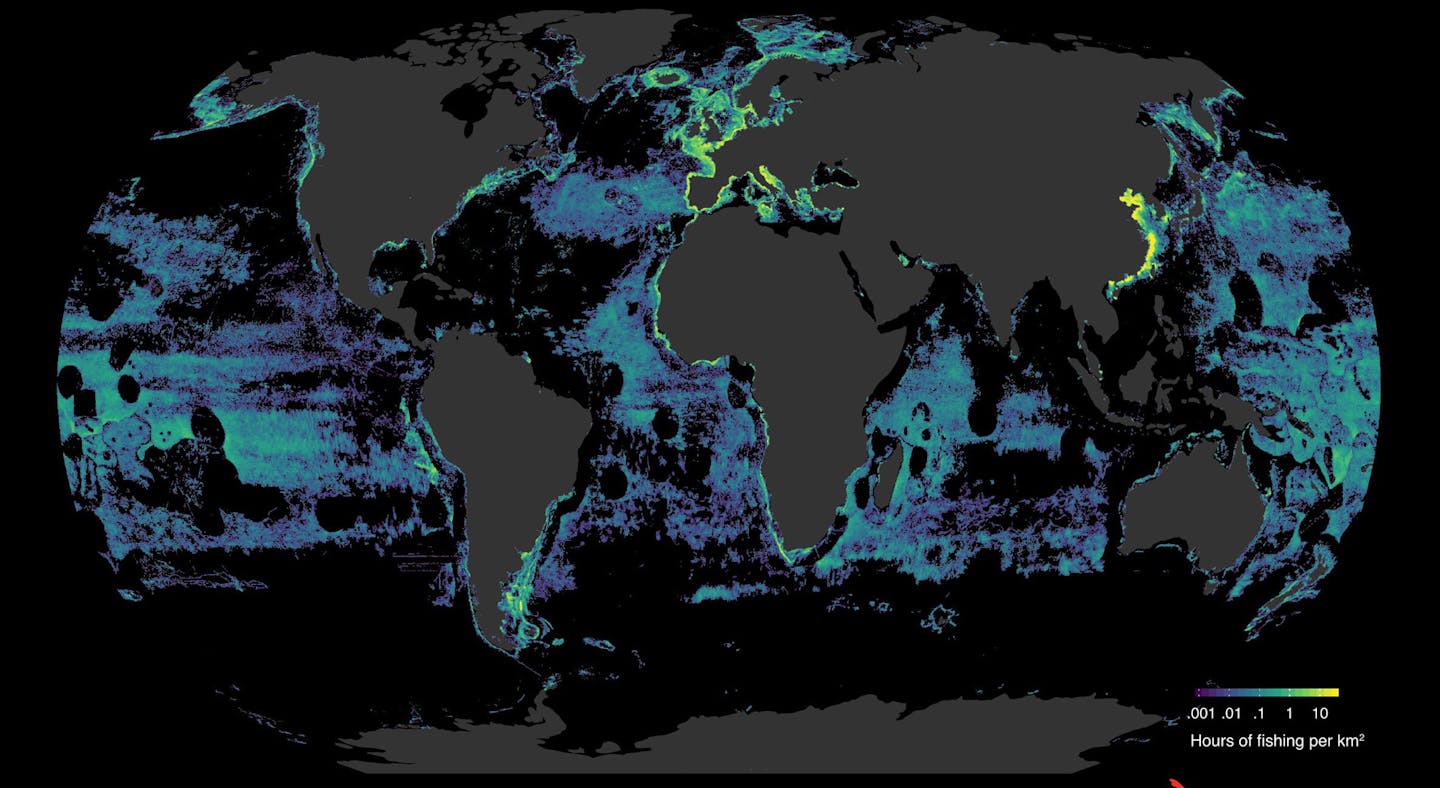
Last month, the journal Science published a remarkable new study that reveals the staggering expanse of global fishing in unprecedented resolution. More than 55% of the ocean surface is subject to industrial fishing. By area, fishing's footprint is now over four times that of agriculture.
Five countries — China, Spain, Taiwan, Japan and South Korea — account for over 85% of observed fishing effort on the high seas.
The study also shows that significant regions of our ocean are not heavily fished, and these areas may offer opportunities for high-impact yet low-cost marine conservation.
The Leonardo DiCaprio Foundation recognized early the huge potential in making our data and visualizations available to researchers to interrogate. Crucially, the dataset used in the study is downloadable via our website and available for free.
Cutting edge technology
This new high-definition view would not have been possible without recent advances in computing power, an increase in satellites in orbit, and improved machine learning that have produced ground-breaking new datasets.
To capture the picture, Global Fishing Watch’s research director, David Kroodsma, and partners at the University of California, Santa Barbara, the National Geographic Society’s Pristine Seas project, SkyTruth, Dalhousie University, Stanford University, and Google analyzed 22 billion messages publicly broadcast from vessels’ Automatic Identification System (AIS) positions between 2012 and 2016.
AIS is an open broadcast of a ship’s identity and location. It is primarily designed as a safety mechanism to avoid collisions at sea but intelligence on behavior and likely activity can be derived by analyzing the identity, speed and direction of broadcasting vessels. This sort of analysis would take a human many days, whereas the machine learning based algorithms have it done in a fraction of the time.
Fishing intensity
The study identified more than 70,000 commercial fishing vessels, their size and engine power, what type of fishing they engaged in, and when and where they fished down to the exact hour and square kilometer.
In 2016 alone, tracked vessels traveled more than 460 million kilometers — a distance equivalent to traveling to the Moon and back 600 times – and resulted in more than 40 million hours of fishing.
Tackling unknowns to protect ocean health
We can now answer questions that were previously unanswerable. Through our research partner program, we’re using the data to interrogate intractable problems and create actionable insights, whether that be identifying optimal regions for fishing closures, or studying the overlap between fishing and vulnerable species to determine where better protection is needed.
These capabilities arrive not a moment too soon.
Oceans are essential for our survival. They regulate the climate and are a vital food source for billions of people. We’ve been fishing the oceans for over 42,000 years, and today the seafood sector provides jobs and income for over 200 million people. But overfishing and illegal fishing are taking a terrible toll on our oceans and action is urgently needed to reverse the decline.
Global Fishing Watch is committed to being part of the solution. We’re growing our collaboration with governments, business, NGOs and research institutes to create and share insights and advance ocean sustainability through increasing transparency.