

Apure-Villavicencio Dry Forests
The ecoregion’s land area is provided in units of 1,000 hectares. The protection goal is the Global Safety Net (GSN1) area for the given ecoregion. The protection level indicates the percentage of the GSN goal that is currently protected on a scale of 0-10.
Bioregion: Llanos & Dry Forests (NT22)
Realm: Southern America
Ecoregion Size (1000 ha):
6,869
Ecoregion ID:
520
Conservation Target:
40%
Protection Level:
6
States: Venezuela, Colombia
The Colombian four-eyed frog, named for its unmistakable “false eyes” on its rear, can been seen along the verdant green gallery forests transecting the Apure-Villavicencio Dry Forests. This transitional ecoregion is sandwiched between the montane forests of the eastern Andean slope and the lowland Llanos savannas of Colombia and Venezuela. For an amphibian, Colombian four-eyed frogs thrive in these surprisingly dry climates, seeking refuge in small perennial pockets of water in this ecoregion’s mosaic of premontane forest, dry forest, savanna, and gallery forest.
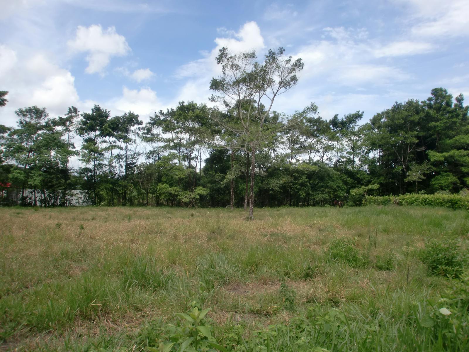
The Apure-Villavicencio Dry Forests border the eastern Cordillera de Mérida from Venezuela to the Serranía de Macarena in Colombia. The forests lay approximately 100–400 m above sea level, with the lower areas found on the eastern side of the ecoregion. Precipitation averages 135 mm annually, and temperatures range between 19–33°C. This area represents a transition zone in both Colombia and Venezuela between the Llanos savannas and the moist montane forests along the eastern slopes of the Northern Andes.
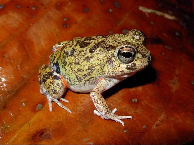
The flagship species of the Apure-Villavicencio Dry Forests ecoregion is the colombian four-eyed frog. Image credit: Creative Commons
Due to human alteration, plant types are fragmented throughout the ecoregion. Some of these formations contain native semi-deciduous woodlands, deciduous thorn forests, and tall grasslands. The deciduous thorn forests are principally found in the Venezuelan side of the ecoregion, and include broadleaf caper, Sonoran palo verde, evergreen shrubs, mesquite, and leguminous tree species. The tall grasslands include dense herbaceous growth in some areas, with species of palm tree, locustberry, and sandpaper tree.
The area between the Uribante and Arauca Rivers in Venezuela is described as a Pleistocene forest refuge with lowland tropical plants. This refuge lies on forested lowlands, with species that are more affiliated to the western Amazon. The plants in the alluvial fans, which are formed when a river slows and creates fan-shaped deposits of sediment, include some 230 species in over 170 genera and 72 families in Colombia alone.
Over 65 reptile species and 144 bird species are represented in the alluvial fans of this ecoregion. Little information exists for the rest of the ecoregion. Endemic terrestrial mammals include a mouse opossum and Hummelinck’s vesper mouse. Mouse opossums are well adapted to dry habitats and can be found in fragments of deciduous forest, while the vesper mouse is mainly found in sandy grasslands.
%20resting%20in%20tree.%20Live%20in%20the%20forest%20of%20central%20South%20America%2C%20Brazil%20dreamstime.jpeg)
Spider monkey. Image credit: Steven G. Johnson, Creative Commons
Most of the area has been highly degraded by agriculture and livestock grazing. In Venezuela, agricultural lands occupy the north of the ecoregion. In the Colombian portion, agricultural lands extend throughout, except for some natural habitat remaining in the lowlands of the Serranía de la Macarena and Tinigua National Parks. These two parks are the only protected areas located in the southernmost part of the ecoregion.
Only small portions of this ecoregion are contained in national parks. Sierra Nevada National Park (IUCN Category II) encompasses the high páramo, moist montane forest, and some of the dry forests of this ecoregion. Serranía de la Macarena National Park (IUCN category II), located in the south of the region, contains savannas, dry forests, tropical lowland forests, and montane forests. However, human activities have deteriorated portions of this park. The Tinigua National Park (IUCN category II) is in a valley between the Sierra Macarena and the East Andes. Most of the park consists of tropical lowland forest.
Logging, agriculture, and livestock grazing have severely altered the landscape, and hunting in the southern region threatens local wildlife. The illegal commerce of coca has caused further environmental degradation on the Colombian side of the ecoregion. Water pollution from oil refining in the Arauca River, on the border of Colombia and Venezuela, also threatens the area.
The priority conservation actions for the next decade will be to: 1) work with local communities to create extractive reserves and protected areas in the southernmost portion of the ecoregion where they are lacking; 2) increase research effort into the biodiversity of the ecoregion; and 3) enable restrictions to limit the conversion of native dry forest into agriculture, and establish best practices of land use so that converted lands remain productive and diminish demand for new land.
Citations
1. Locklin, C. 2018. Northern South America: Colombia and Venezuela. https://www.worldwildlife.org/ ecoregions/nt0201. Accessed June 23, 2018.
2. Rangel, J. O., M. Aguilar, and P. Lowy. 1987a. Parque Nacional Natural Sierra de la Macarena. Colombia Diversidad Biotica I. INDERENA-Universidad Nacional de Colombia, Bogota, Colombia.
3. Rangel, J. O., H. L. P. Sanchez, M. Aguilar, and A. Castillo. 1987b. Region de la Orinoquia. In J. O. Rangel (editor), Colombia Diversidad Biotica I. INDERENA-Universidad Nacional de Colombia, Bogotá, Colombia.
4. Enrique La Marca, Frank Solís, Roberto Ibáñez, César Jaramillo, Querube Fuenmayor, Robert Reynolds, Miguel Trefaut Rodrigues, Abraham Mijares, Ross MacCulloch. 2010. Pleurodema brachyops. The IUCN Red List of Threatened Species 2010: e.T57283A11599287.

Subscribe to receive monthly updates on climate solutions, environmental heroes, and the profound beauty and wonder of our shared planet Earth.
