Global Safety Net (OE) | Dynamic Modeling of Land Areas Essential for Biodiversity and Carbon Storage (GSNx)
Mission: To empower governments, businesses, and the broader public with actionable data to inform the protection, restoration, and connectivity of ecosystems necessary for preserving biodiversity and stabilizing the Earth’s climate.
Introduction
The landmark scientific study, “A Global Safety Net to reverse biodiversity loss and stabilize Earth’s climate” published in Science Advances (Dinerstein et al. 2020) provided the first comprehensive analysis of the world’s intact ecosystems, highlighting the interconnections between biodiversity and climate change. Along with the companion paper, “The Global Deal for Nature” (Dinerstein et al. 2019), the Global Safety Net (GSN) is cited by more than 300 scientific publications with over a billion earned media impressions. The GSN is a primary source for the 30x30 conservation target adopted by the High Ambition Coalition, numbering more than 70 countries. The GSN also is also referenced in the 2021 G7 communique and in Motion 101, which passed at the 2021 IUCN Congress, identifying 50% as a long-term global land conservation target.
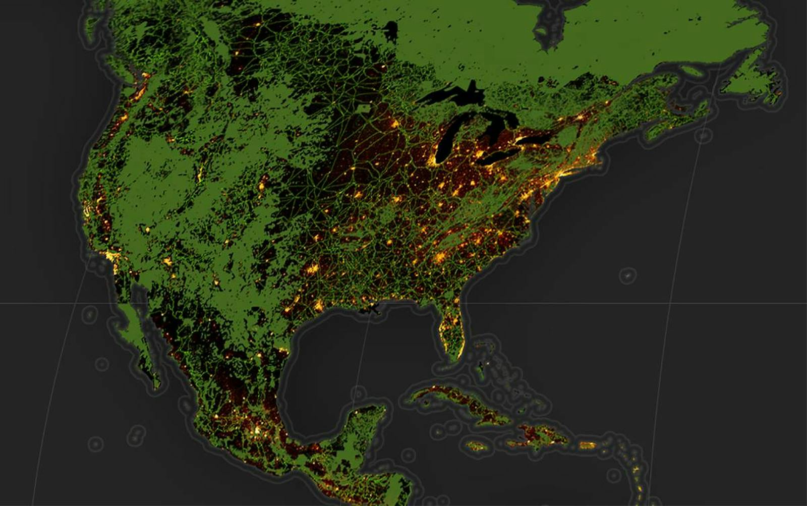
The GSN paper finds that approximately 50% of the world’s lands are in a natural or seminatural condition capable of providing biodiversity habitat, storing at least 50 tonnes of carbon per hectare. The analysis is organized in six layers -- protected areas, rarity sites, high biodiversity areas, large mammal assemblages, intact wilderness, and additional climate stabilization areas. In total, these areas hold two trillion tonnes of carbon (including soil C), absorbing one-quarter of global annual CO2 emissions. The data were compiled at 1km resolution, offering for the first time scientifically derived area-based conservation targets for every country and region. The Global Safety Net, along with its online data platform (GSNapp.org), was recognized as a “World Changing Idea” by Fast Company and has thousands of monthly active users from over 180 countries.

Numbers in parentheses show the percentage of total land area contributed by each of six map layers in the ‘Global Safety Net’ (Dinerstein et al. 2020). Unprotected areas of particular importance for biodiversity, drawn from nine global-scale biodiversity data sets, encompass 14.6% of global land, augmenting the current 15.1% of protected land area. Additional intact wilderness and climate stabilization areas add a further 20.7% of the terrestrial realm.
GSNx Goals
Phase I of the project, completed in 2020, required the compilation of data at 1 km resolution. Phase II of the GSN project (GSNx) introduced here, will deliver a greatly enhanced 100m resolution open-source map hosted on a dynamic mapping platform, bringing together essential biodiversity features, land use data, and carbon mapping. GSNx will provide a powerful tool to inform national and subnational conservation planning efforts, supply chain analysis, and local community action.
New datasets presented in Phase II include high resolution land cover and fractional gradient maps. These components will improve classification, for example, of natural forest versus tree plantations, and pastureland versus native grassland. This enhanced dataset will also help to accurately identify restorable areas within a Responsible Development framework via a novel Dynamic Global Vegetation Model developed by University of Exeter and University of Melbourne (see below).
GSNx will continue to support parties to the Rio conventions with the goal of driving greater ambition to protect and conserve intact ecosystems before we reach dangerous ‘tipping points’ that could drive the potential collapse of critical biosphere functions (Bergstrom et al. 2021). GSNx will ingest and visualize higher resolution datasets, making the application increasingly useful to help: (1) support countries that lack scientifically robust plans to accelerate the process of identifying critical areas for biodiversity protection, connectivity, and carbon storage; (2) inform the commercial sector about high-risk ecosystems threatened by supply chain sourcing or ecologically destructive financial investments; (3) empower indigenous groups and local communities to play a central role in developing and meeting global targets; and (4) enable civil society to explore conservation scenarios at fine scales -- allowing states, provinces, and districts to align local efforts with national or global targets.
Partners
The GSNx project has formed a group of core partners, including RESOLVE led by Eric Dinerstein, the Center for Global Discovery at ASU led by Greg Asner, University of Minnesota led by Anup Joshi, and WCMC/UNEP led by Neil Burgess and Nina Bhola focusing on integration of the World Database on Protected Areas (PAs), Other Effective Conservation Measures (OECMs), and Indigenous & Community Conservation Areas (ICCAs). The dynamic app and public interface design will be developed by Earthrise Media led by Dan Hammer. Google Earth Engine has agreed to continue its support for the initiative through compute time and technical capacity. A group of affiliated NGOs will advise on the design and development of the web application to make it as impactful as possible, including Amazon Frontlines focusing on Indigenous land rights and Canopy focusing on supply chain transitions. The Global Safety Net is housed as a sponsored project of One Earth 501(c)(3).
Scope of Work
Phase II of the Global Safety Net project, commencing 2022 (GSNx), has two major component projects:
- Composite 100m Data Analysis
- Dynamic Online Web Application
1. Composite 100m Data Analysis (GSN2)
The first iteration of the Global Safety Net was a feat of geospatial statistics, compiling numerous data sets at disparate scales to produce a uniform global-scale stock taking of the spatial extent of natural lands by ecoregion at 1 km resolution. The new composite analysis, led by Eric Dinerstein at Resolve and Greg Asner at ASU, will produce a greatly enhanced data product at 100x the resolution of GSN1, solving several critical problems identified in the earlier version.
The first major problem revealed by GSN1 is that many areas currently designated as important for biodiversity in legacy data sets (e.g., Key Biodiversity Areas) are now classified as ‘built-up’ or have been converted to cultivation. A close-up section of the GSN1 map in southern Ghana illustrates this problem:
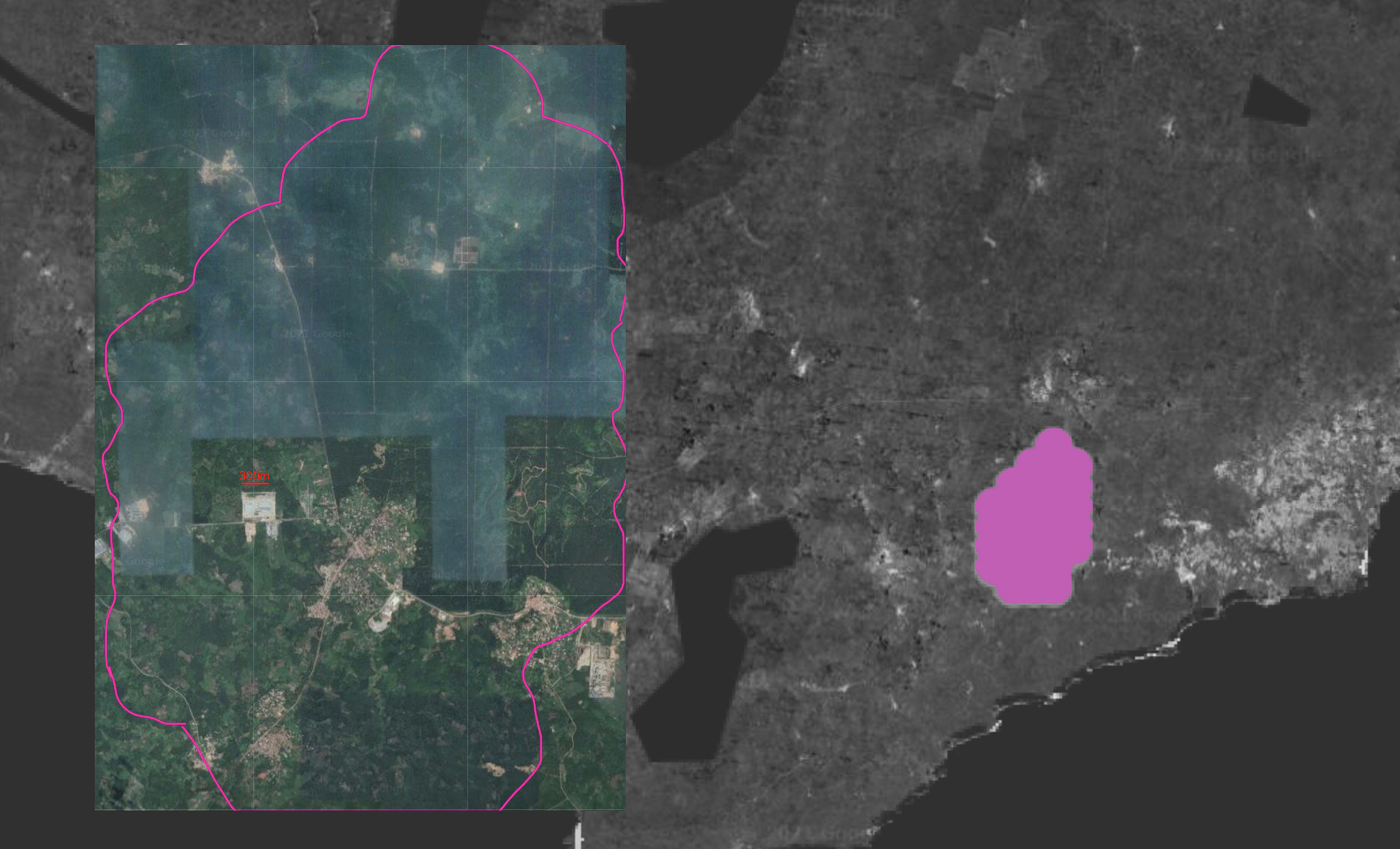
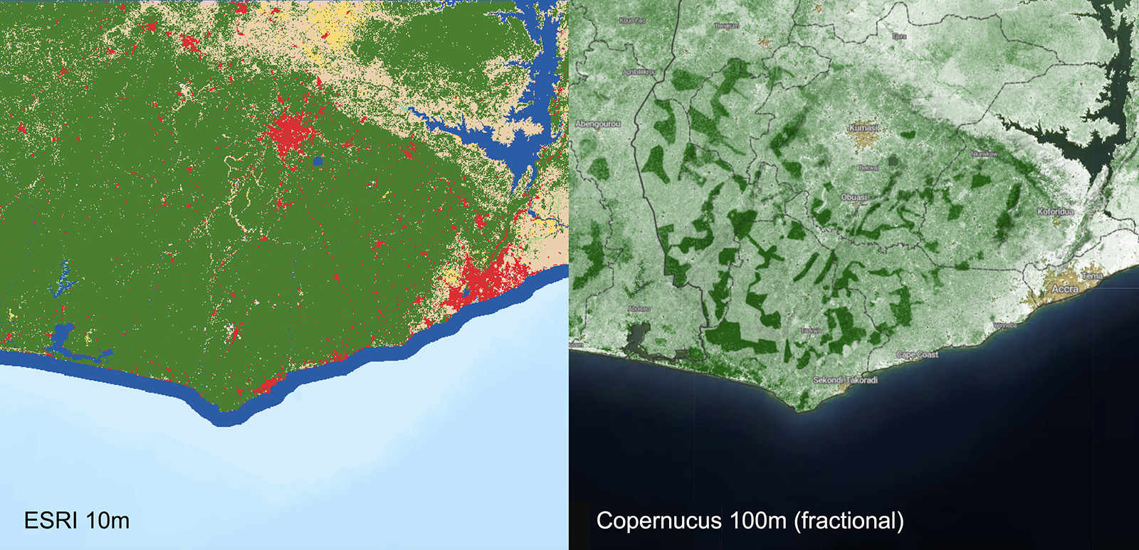
In the GSN1 analysis, the full spatial extent of the area inside the pink bubble (right) is counted towards Ghana’s inventory of natural lands supporting rare species. In reality, we can see in the zoomed-in polygon (left) that a large percentage of this land is now built-up or converted to agricultural use. The problem cannot be solved by using the new 10m land cover maps. A fractional gradient process (i.e. Copernicus 100m land cover) or comparable method is required to screen out these converted areas. In the example below, a fractional gradient applied to forest cover reveals much of the area depicted above is now in cultivation for palm oil, though it appears to be forest in standard land cover classifications:
A new scope of work in the GSN2 analysis will create a composite rarity layer (pink) depicting areas of particular importance for rare species, utilizing data sets published in the scientific literature, covering both plant and vertebrate rarity. The full extent of this new layer will be screened to remove converted land areas and compared against the IBAT rarity layers (KBAs, AZEs, and IUCN sites) to determine the extent of overlap. Note: the previous GSN analysis only examined rarity sites outside of existing Protected Areas. The new analysis will encompass the full extent of rare species areas, including both protected and unprotected areas.
A second problem identified by the GSN centers on properly accounting for the extent of surface water. The previous rarity layer in some cases treats surface water as part of the extent of land area, resulting in larger land area totals. A close-up section of the GSN1 map in northern Guyana (left) illustrates this issue when comparing it to a version with an applied surface water mask
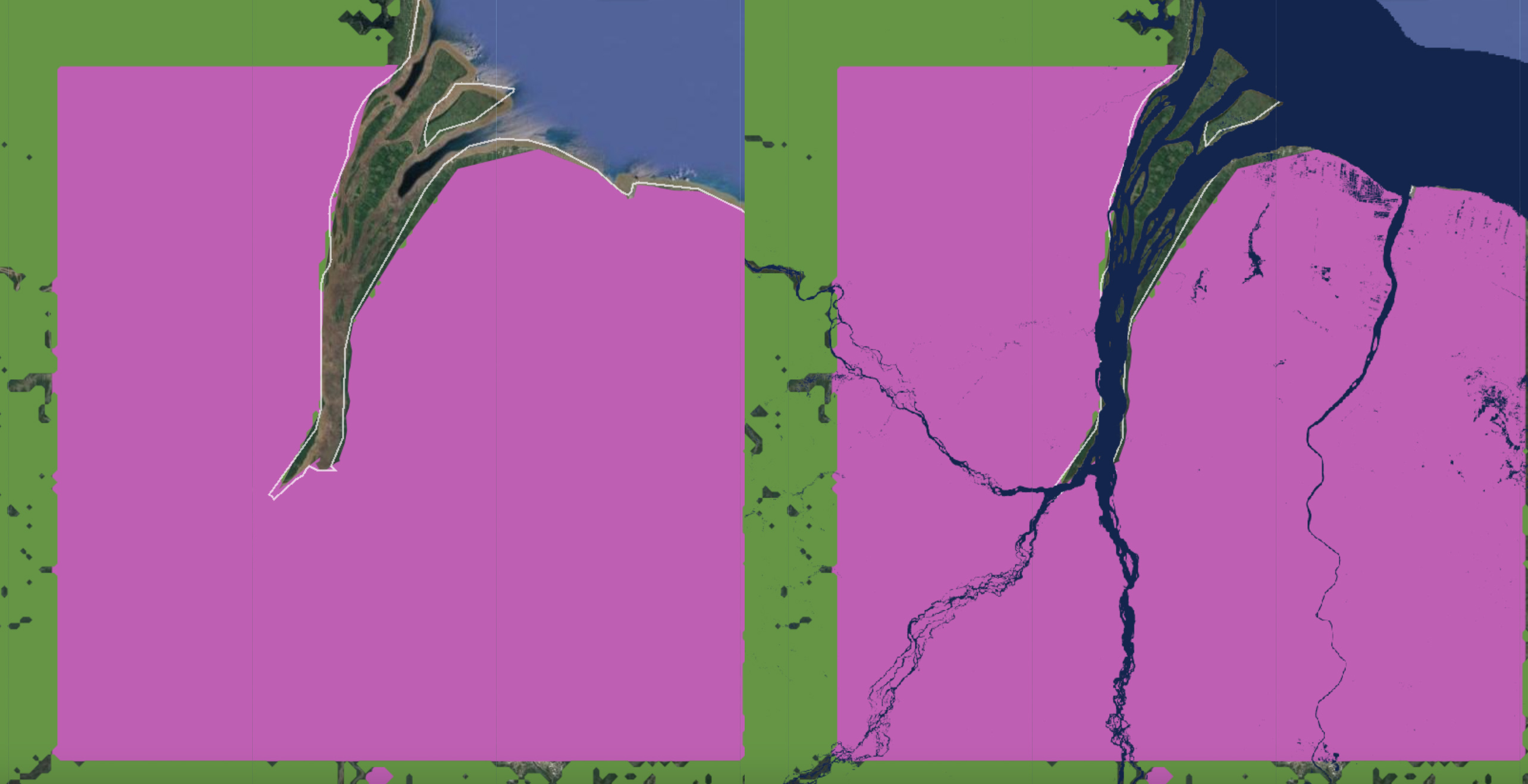
It should be noted that the same issue identified in Ghana regarding converted lands applies as well to the case in Guyana. At least 10% of land area depicted above in the rarity “pink” layer is now built-up or converted to agricultural use. The revised layer will be screened to remove not only these converted land areas but also rivers and streams, utilizing the newly available 10m land/water classification products (e.g. Google’s Dynamic World). This process will be applied on all 6 component layers of the GSN. Seasonal floodplains will be differentiated from rivers and streams.
A third problem pertains to layers depicting wilderness and intactness areas (medium blue) and additional climate stabilization areas (light blue). These layers were derived using land cover data sets and cross-referenced with Anthromes, resulting in coverage gaps where areas of natural land are missed in some landscapes. A close-up section of the GSN1 map in southeastern Idaho illustrates this issue. Compared with the Copernicus fractional land cover map (right), it appears that some important forest fragments are missed, outlined in bright green (left). In the example below, the area below Pocatello is particularly critical given it connects two existing protected areas:
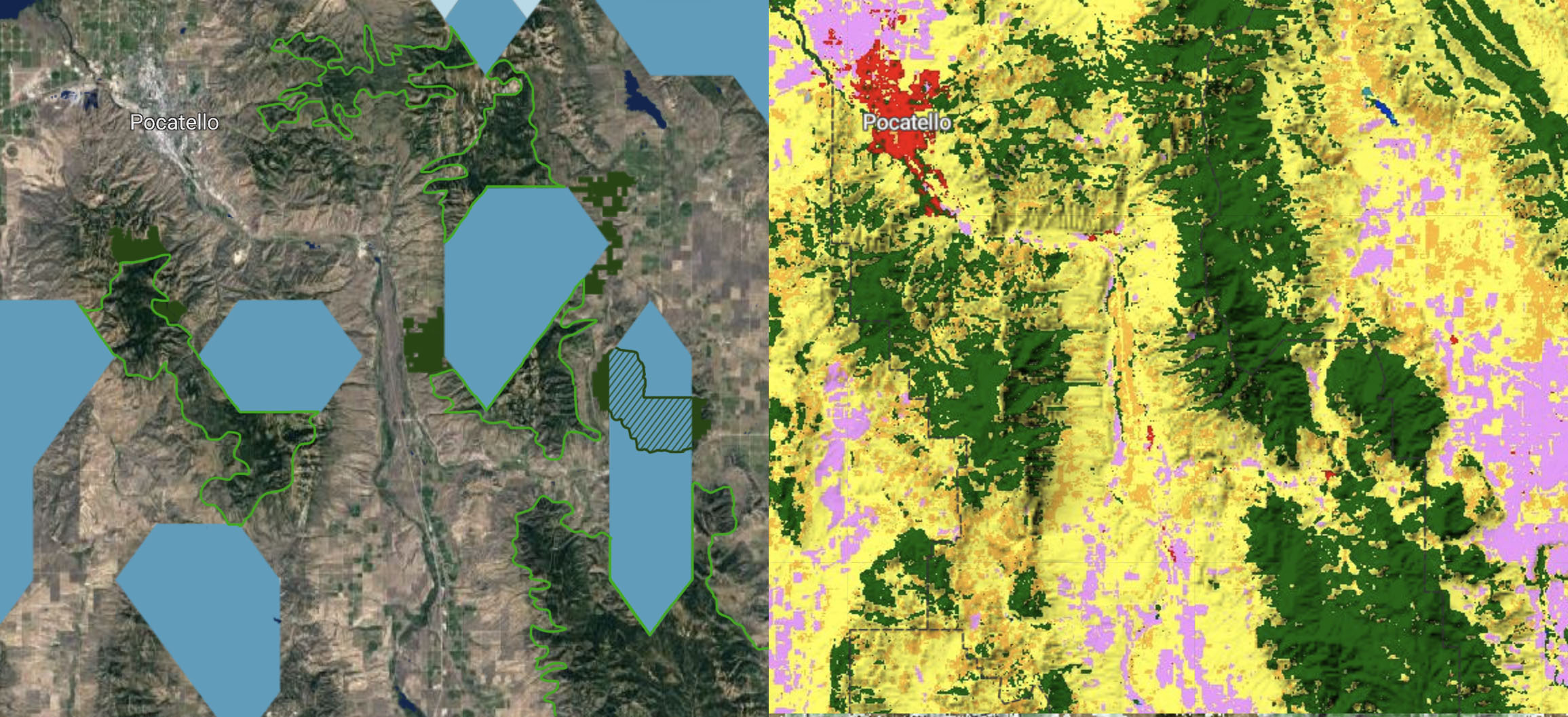
Another issue demonstrated here is the need for dynamically integrating current updates from the World Database on Protected Areas into the GSN. The area indicated by the dark green hatch (left) is in fact protected, but at the time of the GSN1 analysis, it was shown as unprotected land. This will be addressed by the new dynamic GSNx platform discussed below.
The GSN2 analysis will commence in January 2022 and run for approximately nine months. The effort is organized into six work products:
2a. CSA composite. Develop new unified Climate Stabilization Areas layer (light blue). This will be a global map of all land areas that are not built-up or under cultivation and which store > 50 MtC/ha with a minimum area of 10 ha (and minimum depth of 100 m). This can be thought of as the “base layer” of GSN2, covering its full spatial extent on land. This layer will be derived using Copernicus fractional forest cover maps and/or other methods to remove tree plantations or highly degraded forest areas within forest biomes. For non-forest biomes, Copernicus fractional cropland maps and/or other methods will be used to remove converted lands from grassland, shrubland, wetland, and dryland areas. Once completed, the CSA map will also serve as a mask that can be applied to other layers. Any pixels deselected? from the Climate Stabilization Areas raster will be excluded from other GSN layers.
2b. Rarity composite. Develop new Rare Species Areas layer (pink) based on published literature, including small-range vertebrates (Pimm et al. 2018), plant rarity (Enquist et al. 2019), Biodiversity hotspots, and other sources. The recently updated KBA/AZE + IUCN sites will be acquired from IBAT for reference, and the Climate Stabilization Areas mask will be applied to both maps to remove any lands that are built-up or converted to cultivation at 100m resolution. The spatial extents of the two maps will then be compared to derive an approximate overlap figure by continent.
2c. High Biodiversity layer. Establish the full spatial extent of High Beta Diversity Areas (medium green). The Climate Stabilization Areas mask will be applied to remove any lands that are built-up or converted to cultivation at 100m resolution. Portions of the Rarity composite layer may overlap with the new High Biodiversity layer, as well as Protected Areas, but these will not be subtracted as they were in GSN1.
2d. Large Mammal Assemblages. Prepare the new mapping effort documenting the full spatial extent of land areas critically important for seasonal large mammal assemblages (Vynne-Baker et al. 2022) by applying the Climate Stabilization Areas mask to remove any lands that are built-up or converted to cultivation at 100m resolution. Portions of the Mammal Assemblages layer may overlap with the new High Biodiversity and Rare Species layers, as well as Protected Areas, but these will not be subtracted as they were in GSN1.
2e. Wilderness Areas composite. Establish the full spatial extent of land designated as representing ecoregion intactness (Plumptre et al.) or wilderness (Venter et al.). The Climate Stabilization Areas mask will be applied to remove any lands that are built-up or converted to cultivation at 100m resolution. Portions of the Wilderness Areas layer may overlap with the new High Biodiversity, Rare Species layer, and Mammal Assemblages areas, as well as Protected Areas, but these will not be subtracted as they were in GSN1.
2f. Global composite analysis. The new layers will be stacked in the same sequence as the GSN1 analysis to derive similar tables, providing an updated inventory of the spatial extent of each land class by ecoregion, country, and subrealm. A methodology will be proposed for identified top conservation priorities focused on species rarity and endemism. This will be published as a peer-reviewed paper.
2. Dynamic Online Web Application (GSNx)
Concurrent with the development of the new GSN 100m analysis described above, a novel web application will be created to replace the current Google.app site. The new app provides users with access to the data layers described below, and a series of reference layers, updated periodically with visualizations styled in Mapbox. The new GSNx app will represent a leap forward technologically, allowing users to click on a polygon and retrieve current information about Global Safety Net coverage in their country, region, or state.
The primary function of the Phase II app is similar to the original version, providing straightforward data tables that can be visualized or downloaded, which display the non-overlapping extents (top-down) of each of the six land classes (plus surface water). The default layer stack is:
- 7 [top] surface water (dark blue)
- 6 WDPA (updated quarterly by WCMC, dark green)
- 5 rarity sites (pink)
- 4 high biodiversity areas (medium green)
- 3 large mammal assemblages (light green)
- 2 intact wilderness (medium blue)
- 1 [base] climate stabilization areas (light blue: all natural lands > 50 MtC/ha)
In the map viewer, layers can be turned on and off and reordered with an overlapping display. For example, only the extent of layer 5 areas beyond layer 6 areas will be visible, unless layer 6 is turned off, allowing the full extent of layer 5 to be viewed. Choosing from a set of pre-formatted polygon templates -- Ecoregions, Bioregions, Subrealms, Realms, Countries, States -- allows the user to see the corresponding data in a table or chart format for the given polygon, which can be downloaded as a PDF report. A custom polygon tool would enable individuals to task a data analysis for smaller areas.
For launch, the figures for ecoregion and country will be pre-compiled based on the global composite analysis (2f above), but the new app will be dynamic. On a biannual basis, for example, a new set of WDPA polygons can be uploaded to replace the previous version or automated via an API. These imports would not update the entire map globally -- if a user were to click on a polygon after the data replacement, they would be tasking a new calculation, delivering a table and chart with updated values that can then be stored for faster retrieval by other users.
An additional function of the GSNx app will be to provide more detailed statistics within each of the land classes. A ‘side tray’ UI is envisioned that would provide, for example, the extent of overlaps between the layers (e.g. the % of rarity sites or high biodiversity areas captured within a PA in a given polygon). It would also compile data from important reference layers, including:
- ecoregions - Dinerstein et al. 2017
- primary forest - Mackey et al. (in review)
- harmonized carbon - Soto-Navarro et al. 2020
- carbon flux - Harris et al. 2021
- dynamic restoration (forest) - Littleton et al. 2021
- Global Human Settlement - JRC, 2018
- global threats map - Kennedy at al. (in review)
- Indigenous territories
- IBAT layers (red lists)
- MPA optimizations (30x30)
The purpose of the GSNx web application is to make these essential data layers available to stakeholders in government, civil society, and the broader public to support in the development of conservation targets and land use planning scenarios at the national and subnational levels. For example, UNDP’s ELSA program (hyperlink to ELSA project post), which provides conservation and climate resilience planning support for developing countries, can leverage the GSN in land classification and optimization efforts. The GSN can also aid ratings agencies, companies, and NGOs working to assess potential biodiversity impacts from supply chain sourcing. The application will be part of a larger ecosystem of data products and tools, including Nature Map at WCMC and UN Biodiversity Lab at UNEP.
On the Horizon
One Earth is actively working to grow a coalition of partners to support the evolution of the Global Safety Net for a planned Phase III. Several concepts have been discussed as part of an envisioned future expansion: (1) the incorporation of novel data products, including spectranomics mapping of structural vegetation communities delivered by Planet’s new Carbon Mapper mission in 2023; (2) aggregation of best-in-class ecoregion plans exploring conservation scenarios at finer scales; (3) citizen science contributions, including site inspection and image labeling; (4) Wildlife Recovery Index that identifies suitable habitat and priority sites for rewilding of large mammal faunas; (5) measures of freshwater fish diversity from eDNA surveys of major streams and rivers by 2027; (6) soil and mycelial network maps; (7) integration with ground sensors such as TrailGuard or bioacoustics sensor networks; and more.
Currently, there is no collaborative hub for data scientists working to inform long-term conservation planning efforts at the local, regional, and national levels. During the post-2020 Global Biodiversity Framework implementation period of the UNCBD (through 2030), a repository for actionable data is needed. GSNx can help fill this void by providing open access data to decision makers, allowing an array of stakeholders to align local efforts with national or global biodiversity targets.
About Resolve
RESOLVE is an independent, nonpartisan, nongovernmental organization (NGO) that works across sectors to achieve sustainable solutions to critical social, health, and environmental challenges by creating innovative partnerships where they are least likely and most needed. With a team of organizational leaders, mediators, policy experts, strategists, scientists, and facilitators, RESOLVE supports strategic collaborations through an array of capacities -- mediation and process design, solutions-focused strategies and programs, and a capacity to create and launch self-sustaining social enterprises. Its Biodiversity & Wildlife Solutions Program, led by Dr. Eric Dinerstein, is on the cutting-edge of research and technology efforts to support the conservation of species worldwide.
About the Center for Global Discovery (ASU)
The Center for Global Discovery & Conservation Science leads scientific and technological research focused on mitigating and adapting to global environmental change through advanced geospatial mapping and monitoring, remote sensing, and artificial intelligence. Housed at ASU, recognized as the #1 scientific institute in the United States, the center hosts nine research laboratories and leads numerous projects, including the Allen Coral Atlas, the Airborne Observatory -- which pioneered novel spectranomics remote sensing technologies -- as well as the machine learning and AI deployment for Carbon Mapper in partnership with Planet Labs, which will deploy new advanced satellite sensors in 2023.
About One Earth
One Earth is a nonprofit organization working to accelerate collective action to solve the interconnected crises of climate change and biodiversity loss. The solutions for the climate crisis already exist, and the latest science shows we can achieve the 1.5°C goal through three pillars of action – a shift to 100% renewable energy by 2050, protection and restoration of half of the world’s lands and oceans, and a transition to regenerative, climate-friendly agriculture.

Subscribe to receive monthly updates on climate solutions, environmental heroes, and the profound beauty and wonder of our shared planet Earth.