

Cape Verde Islands Dry Forests
The ecoregion’s land area is provided in units of 1,000 hectares. The conservation target is the Global Safety Net (GSN1) area for the given ecoregion. The protection level indicates the percentage of the GSN goal that is currently protected on a scale of 0-10. N/A means data is not available at this time.
Bioregion: Cape Verde Islands (AT24)
Realm: Afrotropics
Subrealm: Sub-Saharan Afrotropics
Ecoregion Size (1000 ha):
457
Ecoregion ID:
31
Conservation Target:
11%
Protection Level:
3
States: Republic of Cape Verde
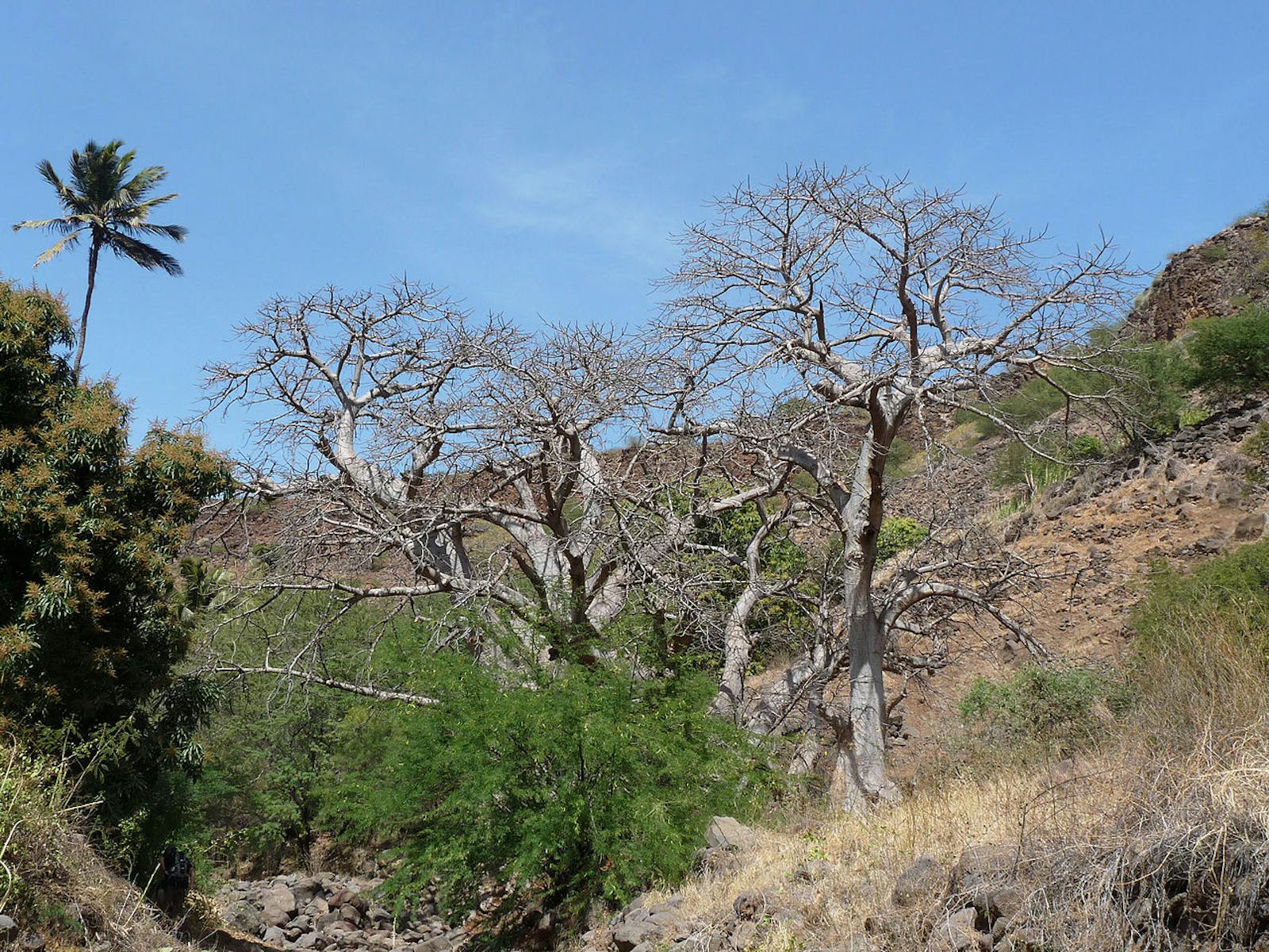
The Cape Verde Islands are a volcanic archipelago featuring jagged mountains as well as comparatively flat plains. Biogeographically they are part of Macronesia, together with the Canary Islands ecoregion (with which they share some affinities). They are home to a number of endemic plant and vertebrate species, particularly birds and reptiles including the critically endangered Raso lark, Cape Verde shearwater, and the endangered giant wall Gecko. The islands’ beaches are also globally important nesting areas for loggerhead turtles.
The Cape Verde Islands consist of ten islands and five islets and are located in the eastern Atlantic Ocean approximately 500 km from the coast of Senegal, West Africa. The total land area for the archipelago is 4,030 km2, scattered over 58,000 km2 of ocean. The landscape is rugged on the younger islands (Fogo, Santo Antão, Santiago, and São Nicolau), with peaks reaching over 2,000 m (the highest mountain is the active volcano Mount Fogo, 2,829 m), but relatively flat on the older islands (Maio, Sal, and Boa Vista).
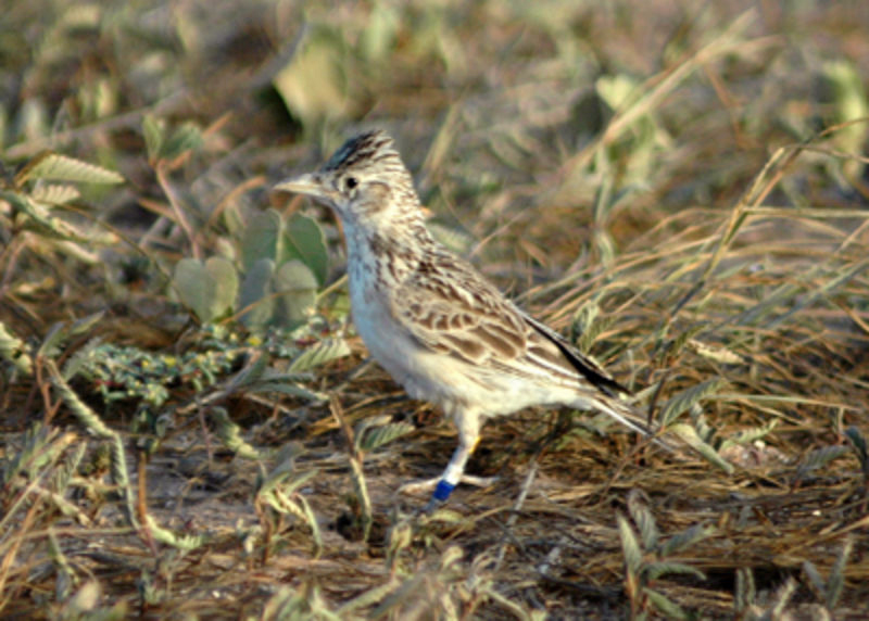
The flagship species of the Cape Verde Islands Dry Forests ecoregion is the raso lark (Alauda razae). Image credit: Justin Welbergen, CC BY-SA 3.0
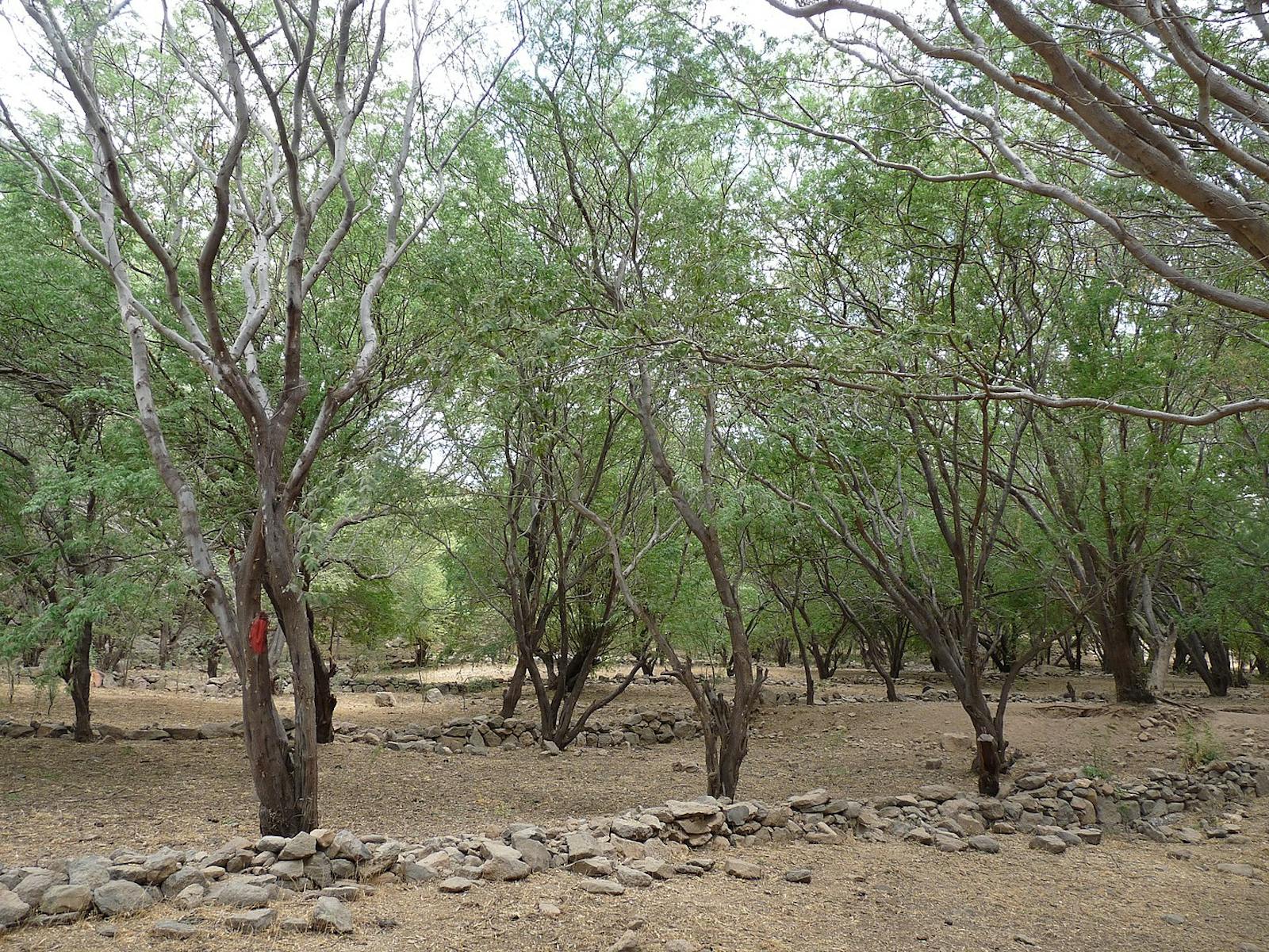
Cape Verde has a tropical climate with a dry season from December to July and a warm and wet season between August and November. The islands are part of the arid belt on the African mainland in the Sahelian region, and periodically suffer from prolonged droughts and serious water shortages. The mountainous islands receive significantly more rainfall than the lower, flatter islands. Some places have an annual rainfall around 1,200 mm, whereas others have basically no rainfall for years at a time. Temperatures range between 20° and 40°C, and average between 25° and 29°C. The volcanic soils are fertile, but most parts of the islands are too arid for agriculture. These islands once supported savanna or steppe vegetation on the lower parts of the islands, with an arid shrubland at higher altitudes; much of the native vegetation is drought-resistant.
Out of 180 native plant a species, approximately half are endemic. The other 441 flora species occurring on these islands were introduced by humans. Out of a total of 171 bird species, four species of land bird are endemic, including the Iago sparrow and Alexander’s swift, which occur on at least nine of the ten major islands.
The other two endemic species have a narrower distribution—the critically endangered Raso lark on Raso Islet and the Cape Verde warbler on three islands. In 2018, a team of biologists reintroduced 30 individuals of the Raso lark onto Santa Luzia island, bringing them back to one of their historical homes for the first time in 500 years after human colonization.
The islands are also important for rare breeding seabirds including the near-endemic Fea’s petrel as well as the magnificent frigatebird, red- billed tropicbird, the Cape Verde shearwater and white-faced storm-petrel. There are no endemic mammals on the islands, but five species of bats occur, including the naked-rumped tomb bat, Kuhl’s pipistrelle, and Schreiber’s long-fingered bat. Fifteen species of lizards occur, of which thirteen are endemic. Examples include the Cape Verde giant skink on Raso Island and the giant wall gecko found on both Raso and Branco.
In the 500 years since humans first colonized the islands, the loss of natural habitats has been severe. Remaining areas of natural habitat are confined to steep rocky areas and ravines in the mountainous islands and to patches in the flatter islands. There are seven protected areas including three natural parks: Monte Gordo on São Nicolau, Serra de Malagueta on Santiago and Bordeira, and Chã das Caldeiras e Pico Novo on Fogo; as well as 4 Ramsar Sites: Lagoa de Pedra Badejo on Santiago, Curral Velho and Lagoa de Rabil on Boa Vista, and Salinas of the English Port on Maio. Some of protected areas include important habitats for breeding seabirds.
The remaining habitats are all under considerable threats from tourism, overgrazing by livestock, overfishing, improper land use that often results in extensive soil erosion, and the demand for wood that has resulted in deforestation and desertification. Droughts are severe and have increased in the past 20 years due to climate change. The introduction of exotic animals such as rats, sheep, goats, green monkeys, and cattle has had devastating effects on the native flora and fauna. Introduced mammals (e.g., cats, rats, and green monkeys) can ravage nesting areas of seabirds, turtles and endemic reptiles, greatly reducing their in numbers on these small islands.
Over time, these introduced mammals can wipe out entire populations. Local and international NGOs such as BirdLife Portugal and Biosfera have been setting up monitoring teams nearby these breeding colonies protect and facilitate the recovery of these endangered species. Human exploitation of wildlife resources has also been considerable; in particular, the eggs and nestlings of seabirds are a traditional source of food for the islanders as well as the illegal trade of marine turtles for meat. Under the Alcyon project, Birdlife International have been working to build capacity for better management of seabird colonies.
Priority conservation actions for the next decade.
- Build law enforcement capacity to prevent the illegal trade in marine turtles;
- Conserve terrestrial areas, particularly those of ecological importance, through an effective protected areas management body;
- Establish and implement national monitoring and conservation plans for threatened species, including the control and removal of invasive species.
-
-
Citations
1. CEPF. 2017. Ecosystem Profile: Mediterranean Basin Biodiversity Hotspot. [Online]. [Accessed 1 February 2018]. Available from: https://www.cepf.net/sites/default/files/mediterranean-basin-2017-ecosystem-profile-english_0.pdf
2. Hancock, J.M., Furtado, S., Merino, S., Godley, B.J. and Nuno, A. 2017. Exploring drivers and deterrents of the illegal consumption and trade of marine turtle products in Cape Verde, and implications for conservation planning. Oryx. 51(3), pp.428-436.
3. MAHOT. 2014. Estratégia Nacional e Plano de Ação para a Conservação da Biodiversidade 2015- 2030. Direção Geral do Ambiente, Praia- República de Cabo Verde, Pag. 100pp
4. Birdlife International. 2020. Newsletter on Alcyon programme activities. [Online]. [Accessed 14 March 2020]. Available from: https://www.birdlife.org/sites/default/files/attachments/alcyon_newsletter-jan_2020-eng4.pdf -
Cite this page: Cape Verde Islands Dry Forests. Ecoregion Snapshots: Descriptive Abstracts of the Terrestrial Ecoregions of the World, 2021. Developed by One Earth and RESOLVE. https://www.oneearth.org/ecoregions/cape-verde-islands-dry-forests/
-

Subscribe to receive monthly updates on climate solutions, environmental heroes, and the profound beauty and wonder of our shared planet Earth.
