
Gurupa Várzea
The ecoregion’s land area is provided in units of 1,000 hectares. The conservation target is the Global Safety Net (GSN1) area for the given ecoregion. The protection level indicates the percentage of the GSN goal that is currently protected on a scale of 0-10. N/A means data is not available at this time.
Bioregion: Northern Amazonian Forests (NT20)
Realm: Southern America
Ecoregion Size (1000 ha):
995
Ecoregion ID:
467
Conservation Target:
61%
Protection Level:
7
States: Brazil
The scaled spinetail is a bird species endemic to the swamps and flooded forests of the lower Amazon river of Brazil. The species usually forages in pairs or in mixed flocks with other species, chasing and sallying insects on the tree bank (and during the dry season from the forest floor) in the middle and lower canopy. As with most species in the várzea ecoregions, it is adapted to seasonal flooding which might rise as much as 3-6 m. During high water the spinetail remains in the middle canopy near the water line, looking for insects floating by on rafts of vegetation washing down from upstream. To the insects, these floating leaves and branches are literally “life rafts” during floods; but to the opportunistic scaled spinetail, they are buffets.
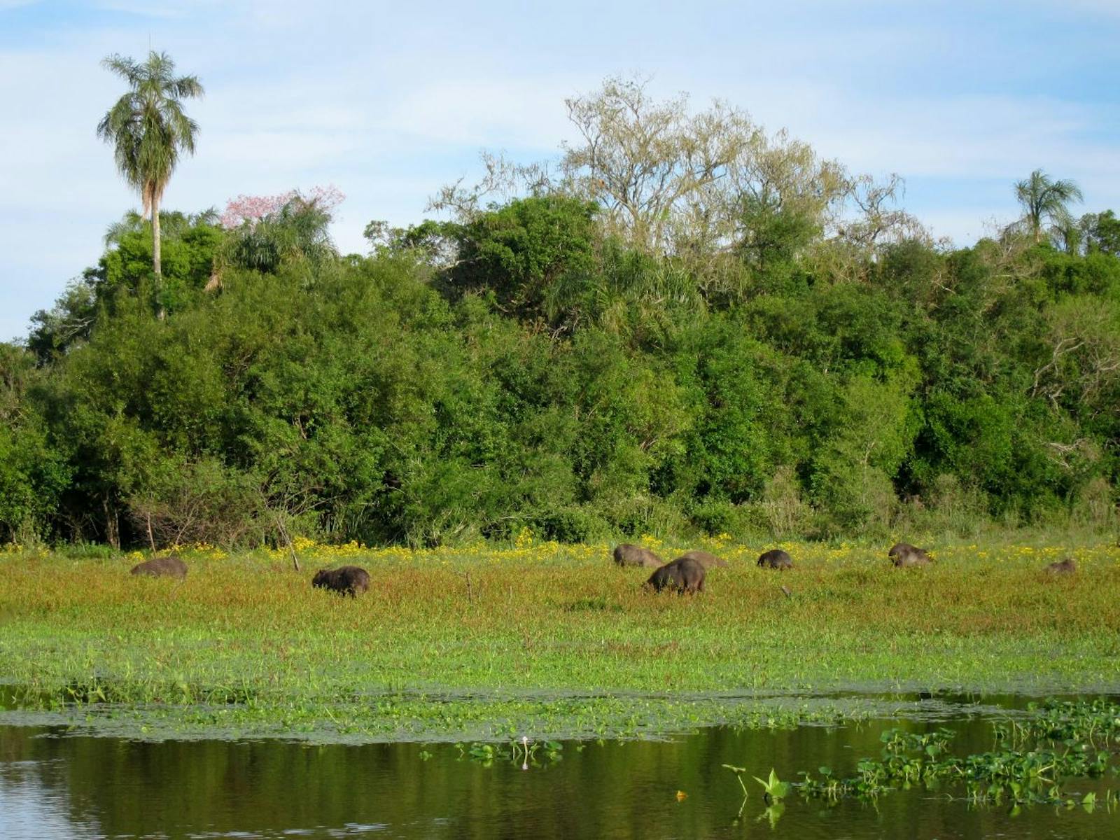
The Gurupa várzea ecoregion is named for the large alluvial island, Ilha Grande de Gurupá, occurring at the mouth of the Amazon River. It is distinct from the flanking várzea ecoregions in that a majority of the landscape is savanna rather than dense tropical forest. Elevation along this region reaches 5 m. Average annual rainfall is below 2,500 mm.
The term várzea refers to a seasonally flooded forest from river overflow. Specifically, for the Gurupa várzea, overflow is caused by rainfall in the drainage basins along the Amazon River and its tributaries and by the daily tide pushing a large volume of river discharge over the landscape. The daily flood level ranges from 4–7 m at the height of the seasonal flood pulse and 2–3 m at the low season. The flooding provides the region with a constant influx of nutrient-rich sediments and accordingly diverse vegetation species.
The most prominent is a variety of trees that produce fleshy fruit and are critical to the survival of fruit-eating species of fish, primates, and bats that enter the forest understory during flooding. Examples include yellow mombin, moriche palm, açaí palm, socoró, and tarumã.
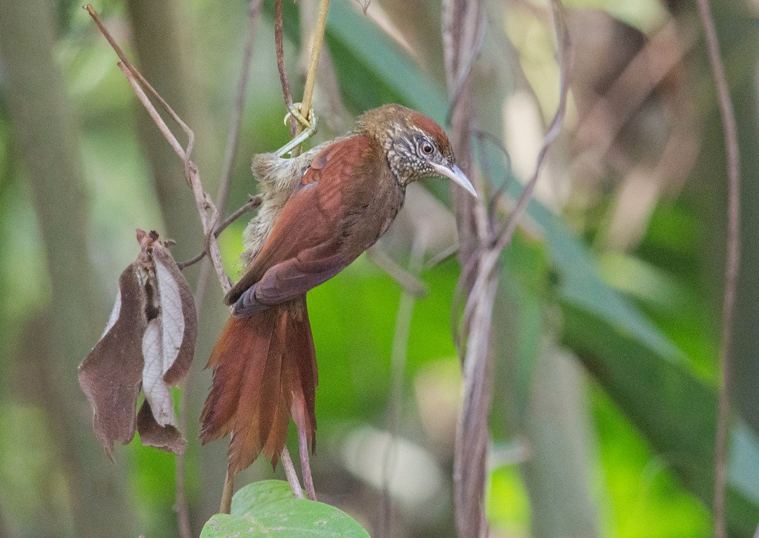
The flagship species of the Gurupa Várzea ecoregion is the scaled spinetail. Image credit: Creative Commons
Within the Gurupa várzea ecoregion there are over 558 bird species including the roseate spoonbill, the vulnerable dark-winged trumpeter, and the scaled spinetail. During flooding the rivers bring in aquatic species, such as the Arrau turtle, as well as several species of fish that use the area as a breeding ground. Examples include large fish like pacu, tambaqui, piraracu, and smaller carnivorous piranha.
This ecoregion hosts 148 mammal species, the largest of which include ocelots, margays, tapirs, capybaras, kinkajous, and the vulnerable white-lipped peccaries. Primates found only here or in a few other Amazonian regions include red-handed tamarin, bare-eared squirrel monkey, red-bellied titi monkey, and silvery marmoset. There are also various species of rats and bats that inhabit the area.
The Amazon várzea has a long history of the human occupation because of its high productivity and accessibility. Principal activities on the Gurupa várzea are subsistence agriculture, fishing, selective logging, and ranching. Much of the forest along these banks of the Lower Amazon has been cleared and the natural savannas altered to expand pasture area for cattle or water buffalo.
The production systems of smallholder farmers tend to be biologically diverse agroecosystems with strong tree-based components, so land degradation does not generally occur where small-scale farmers live. Much of the forest that remains is managed or unmanaged secondary forest. A few urban centers such as Monte Alegre are located on the riverbank in this region, and urban sprawl has replaced some natural habitats. The major commercial timber species, such as baboonwood and kapok tree, are all but depleted in this region.
The habitats in this ecoregion are threatened mostly by human alteration. The flooded savannas are stressed by grazing cattle and water buffalo. The fertile soil of the flooded ecoregion has also attracted large-scale agricultural projects such as jute in the past and mechanized rice production today which degrade the natural habitat. Commercial logging and fisheries extraction pose a threat to the populations of all species.
The priority conservation actions for the next decade will be to 1) limit agricultural activities to small-scale farming; 2) mandate sustainable harvest for the commercial logging and fishing industry, and 3) increase the number of and connectivity of protected areas.
Citations
1. Sears, R. 2019. Northern South America: Northeastern Brazil https://www.worldwildlife.org/ecoregions/nt0126 Accessed January 23, 2019
2. Ferreira, L.V. 2001. A distribuição das unidades de conservação no Brasil e a identificação de áreas prioritárias para a conservação da biodiversidade nas ecorregiões do bioma Amazônia. Ph.D. Dissertation, INPA/UA.
3. Prance, G. T. 1979a. Notes on the vegetation of Amazonia III. The terminology of Amazonian forest types subject to inundation. Brittonia 31: 26-38.
4. BirdLife International 2016. Cranioleuca muelleri. The IUCN Red List of Threatened Species 2016: e.T22702461A93876252. http://dx.doi.org/10.2305/IUCN.UK.2016-3.RLTS.T22702461A93876252.en Accessed January 23, 2019.

Subscribe to receive monthly updates on climate solutions, environmental heroes, and the profound beauty and wonder of our shared planet Earth.
