

Madagascar Humid Forests
The ecoregion’s land area is provided in units of 1,000 hectares. The protection goal is the Global Safety Net (GSN1) area for the given ecoregion. The protection level indicates the percentage of the GSN goal that is currently protected on a scale of 0-10.
Bioregion: Madagascar Island (AT6)
Realm: Afrotropics
Ecoregion Size (1000 ha):
11,235
Ecoregion ID:
17
Conservation Target:
49%
Protection Level:
2
States: Madagascar
Sixty years after its last sighting in 1930, the endemic Madagascac serpent eagle, once thought to be already extinct, was rediscovered in the humid forests of eastern Madagascar. This ecoregion hosts some of the most diverse habitats on this island, and contain exceptionally high levels of endemism. The region harbours the greatest diversity of birds in Madagascar, including some extremely rare species, such as the Madagascar red owl.
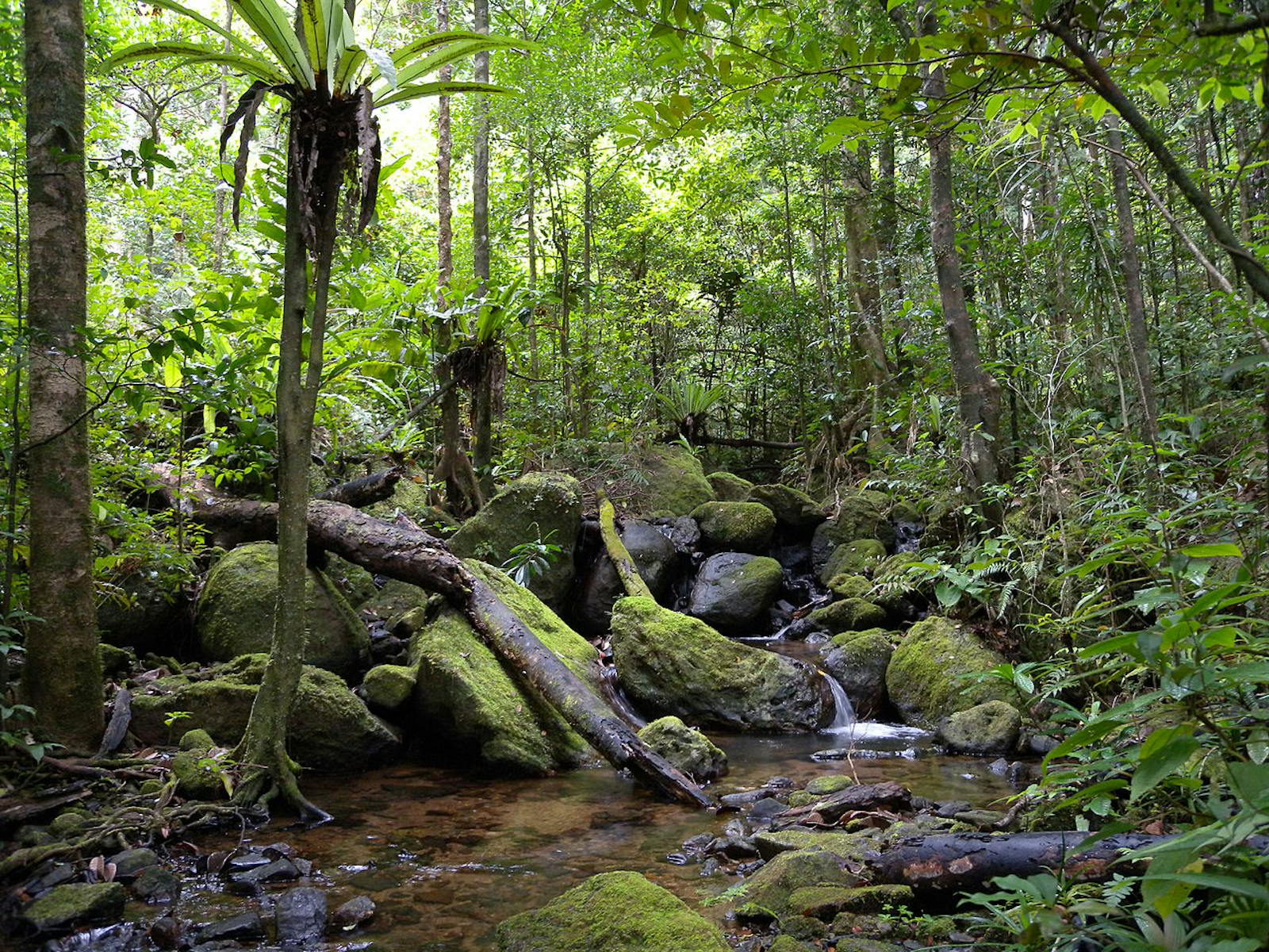
The ecoregion occupies the eastern side of Madagascar, including the littoral forests of the narrow coastal plain and up to the crest of the eastern escarpment around 1,200 – 1,600 m. The eastern escarpment traps humid air from the sea, forming a continuous cloud layer at 900 – 1,200 m. This moisture supports a band of forest from Andravory in the north to Andohalela in the south, with a narrow section along the Angavo Scarp. The two most important factors which distinguish the humid forests from the subhumid forests of the central highlands are the distribution of rainfall and the length of the dry season. Rainfall generally exceeds 2,000 mm per year in the humid forests, and in some areas (such as the Masoala Peninsula) can be as high as 6,000 mm per year. The dry season is less than two months in duration.
Winter mists between May and September also characterize the humid forests. Cyclones occur in some years between December and March, and can cause considerable habitat destruction. In these humid forests, typical canopy species include Dalbergia, Diospyros, Ocotea, Symphonia, and Tambourissa. Species of Canarium, Albizia, and Brochoneura acuminate rise above the canopy as emergents. The lowland forests also have a rich diversity of Pandanus, palm, bamboo, and epiphytic orchid species. At higher elevations the trees become shorter and have a denser undergrowth.
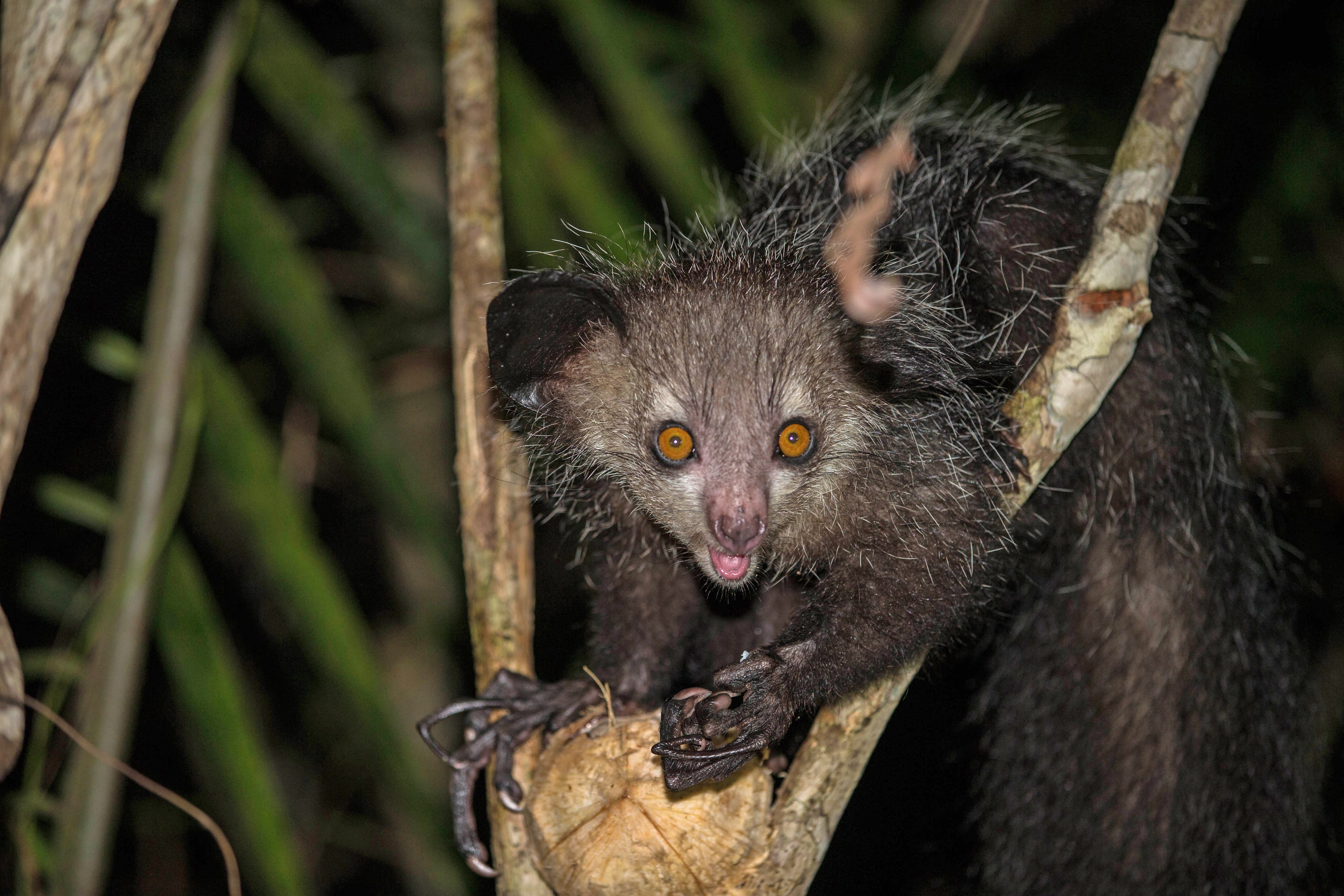
Wild aye aye. Image credit: Nomis Simon, Creative Commons
Plant diversity and endemism is extremely high, for example, 97 percent of the 171 species of Malagasy palms are endemic to the island, and the majority of these are found in the eastern forests. Orchids are also diverse, with many species confined to these eastern forests. The most well-known of them is the Angreaceum sesquipedale or Darwin’s orchid, with a 35-cm long spur that has led the celebrated naturalist to famously predict its pollinator to co-evolve a proboscis of matching length. When the pollinator moth with a 30-cm-long tongue was finally discovered, this has come to be seen as a famous evidence of the theory of evolution.
%2C%20an%20endangered%20frog%20endemic%20to%20the%20eastern%20rainforests.%20Image%20credit%20Frank%20Vassen%2C%20Creative%20Commons.jpg)
Golden mantella (Mantella aurantiaca), an endangered frog endemic to the eastern rainforests. Image credit: Frank Vassen, Creative Commons
The mammal fauna includes all five families of Malagasy primates. Lemurs found here include the recently rediscovered hairy-eared dwarf lemur, two subspecies of ruffed lemurs, eastern woolly lemur, diademed sifaka, Milne-Edwards’ sifaka, golden bamboo lemur, and greater bamboo lemur. Of the 165 breeding bird species recorded in the eastern forests, 42 are endemic to the ecoregion. About 50 species of reptiles and 29 species of amphibians are also strictly endemic to the humid forest ecoregion including an assortment of geckos and a large number of skinks, such as Amphiglosssus astrolabi and A. frontoparietalis.
The forested habitats of this ecoregion have been heavily degraded and fragmented, and much has already disappeared. The littoral forests are among Madagascar’s most impacted vegetation types, with little remaining undisturbed forest, and patches that are too small to support viable populations of large lemurs. The process of deforestation has been going on for centuries and there is intense pressure on the remaining forests.
_male-CC-Charles%20J%20Sharp-2018_resized.jpg)
Greater bamboo lemur. Image credit: Charles J Sharp, Creative Commons
In only a few locations (e.g., Masoala Peninsula) do the forests extend continuously across a significant elevational gradient, starting at sea level. Most large blocks of forest are found in protected areas, such as Masoala National Park, Mananara Nord UNESCO-MAB Biosphere Reserve (including Verezanantsoro National Park), Ambatovaky Special Reserve, and Zahamena Strict Nature Reserve and National Park. Lowland forest outside of protected areas includes the forests near Rantabe in the northeast and the eastern slopes of the northern Vohimena Mountains in the southeast.
-CC-Charles%20J%20Sharp-2018.jpg)
Milne Edward's sifaka. Image credit: Charles J Sharp, Creative Commons
The major threat to the Madagascar lowland forests is the shifting cultivation practice of “tavy”. The forest is cut and burned and the land used to grow crops such as manioc (cassava) and hill rice. After 2-3 years, the land is abandoned and regenerates into bushland and thicket. Ideally, after more than 10 years the land can be used again for agricultural crops. Due to increasing population pressure, fallow periods have become shorter leading to lower crop yields and further pressure on the forests, as they are the only source of new farmlands. Secondary threats to the forest include unintentional burning from wildfires as well as legal and illegal commercial logging. In some areas, over-exploitation of selected forest species for decorative purposes, such as palms and Cyathea tree ferns, can critically undermine the forest’s integrity. The extinction of numerous narrowly endemic species over the next few decades cannot be discounted in this ecoregion.
The priority conservation actions for the next decade will be to: 1) restore natural forests creating continuous corridors between remnant forest habitats; 2) promote farming alternative practices to “tavy”; and 3) strengthen capacity of the forest administration in law enforcement.
Citations
1. Conservation International. 2014. Carbon Emissions Reduction Project in the Forest Corridor Ambrositra-Vondrozo (COFAV), Madagascar. [Online]. [Accessed 30 January 2018]. Available from: https://s3.amazonaws.com/CCBA/Projects/Reduced_Emissions_from_Deforestation_in_the_Ambositra-Vondrozo_Forest_Corridor_(COFAV)-Madagascar_Project/Validation/Update/COFAV+CCBS+PD+2014_01_07_validated.pdf
2. World Bank Group. 2015. Analysis of Community Forest Management (CFM) in Madagascar. [Online]. [Accessed 30 January 2018]. Available from: https://openknowledge.worldbank.org/bitstream/handle/10986/23348/Analysis0of0co000CFM00in0Madagascar.pdf?sequence=1&isAllowed=y
3. Lowry, P.P. II, G.E. Schatz, and P.B. Phillipson. 1997. The classification of natural and anthropogenic vegetation in Madagascar. In: Goodman, S.M and Patterson, B.D. ed. Natural change and human impact in Madagascar. Washington, D.C: Smithsonian Institution Press, pp. 93-123

Subscribe to receive monthly updates on climate solutions, environmental heroes, and the profound beauty and wonder of our shared planet Earth.
