
Nebraska Sand Hills Mixed Grasslands
The ecoregion’s land area is provided in units of 1,000 hectares. The conservation target is the Global Safety Net (GSN1) area for the given ecoregion. The protection level indicates the percentage of the GSN goal that is currently protected on a scale of 0-10. N/A means data is not available at this time.
Bioregion: Southern Prairie Mixed Grasslands (NA20)
Realm: Northern America
Ecoregion Size (1000 ha):
5,916
Ecoregion ID:
395
Conservation Target:
55%
Protection Level:
0
States: United States: NE, SD
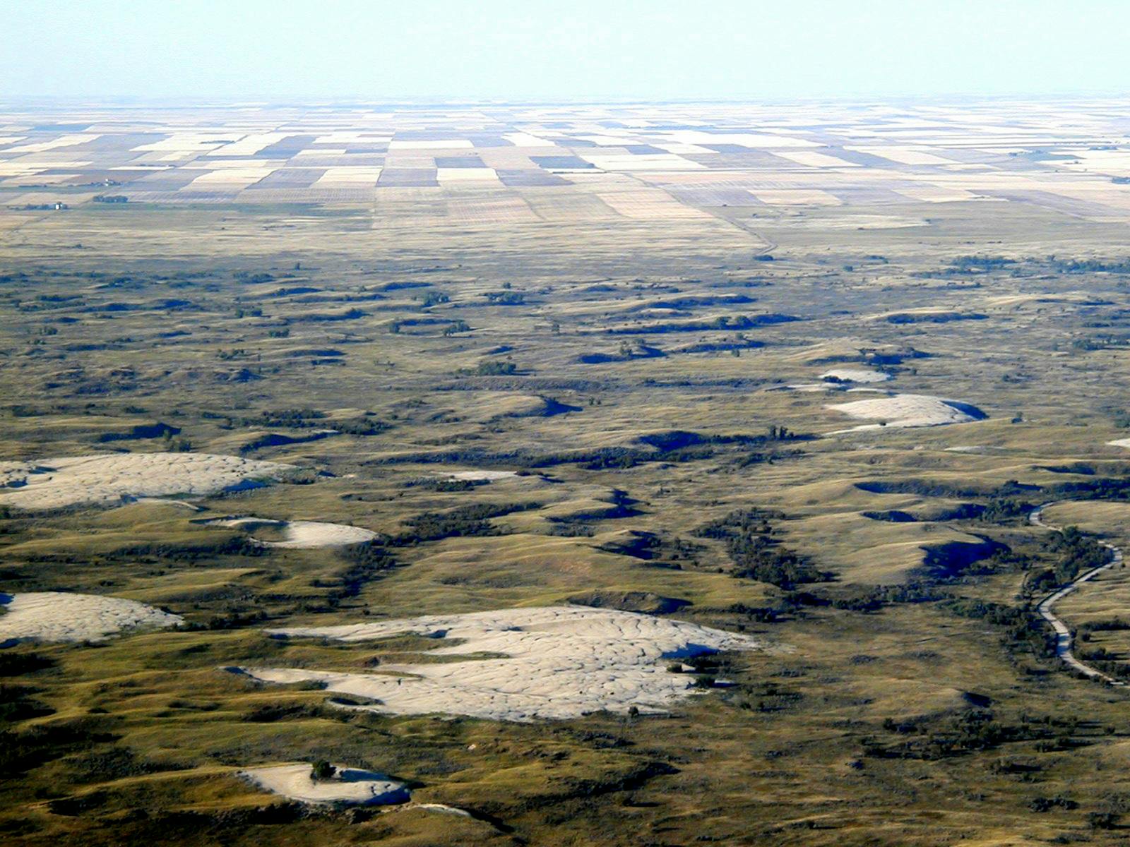
The Nebraska Sand Hills Mixed Grasslands ecoregion is the smallest ecoregion in the Great Plains but stands out as the most intact of all Great Plains ecoregions and, most significantly, as the largest area of sand dunes in the entire Western Hemisphere. Most of the dunes, which may exceed 100 m in height, are stabilized by mixed-grass prairie plants but have been active in the past and may be again with climate change. Although some attempts at farming have been made over the years, including recently with the aid of central-pivot irrigation, the vast majority of the ecoregion is uncultivated. Cattle ranching, however, began in the 1870s, and today more than 530,000 beef cattle occupy the ecoregion.
The climate of the Nebraska Sand Hills Mixed Grasslands ranges from subhumid warm continental to subhumid cold temperate. Annual precipitation is 425–625 mm, with an average annual temperature of 10o C (with extreme contrast between summer and winter) and a frost-free period of 130–155 days. The sand that created the Sand Hills was deposited by ancient rivers draining the Rocky Mountains from Pleistocene to Holocene times. The dunes become active during severe droughts, which have occurred many times during the past 15,000 years.
The most recent period of high dune mobility was during the Medieval Climate Anomaly of 900–1300 C.E.(AD), and before then during the mid-Holocene Climatic Optimum (Hypsithermal Period) 9,000–5,000 years ago. The Sand Hills lie atop the High Plains (Ogallala) Aquifer, and low areas between dunes are wetlands connected to the aquifer, which help replenish the aquifer during rains and snowmelt. Evaporation of water from these wetlands benefits adjacent prairie vegetation on the dunes during droughts. When droughts are severe and prolonged, however, the water table drops, vegetation dies back, and the dunes become active again.
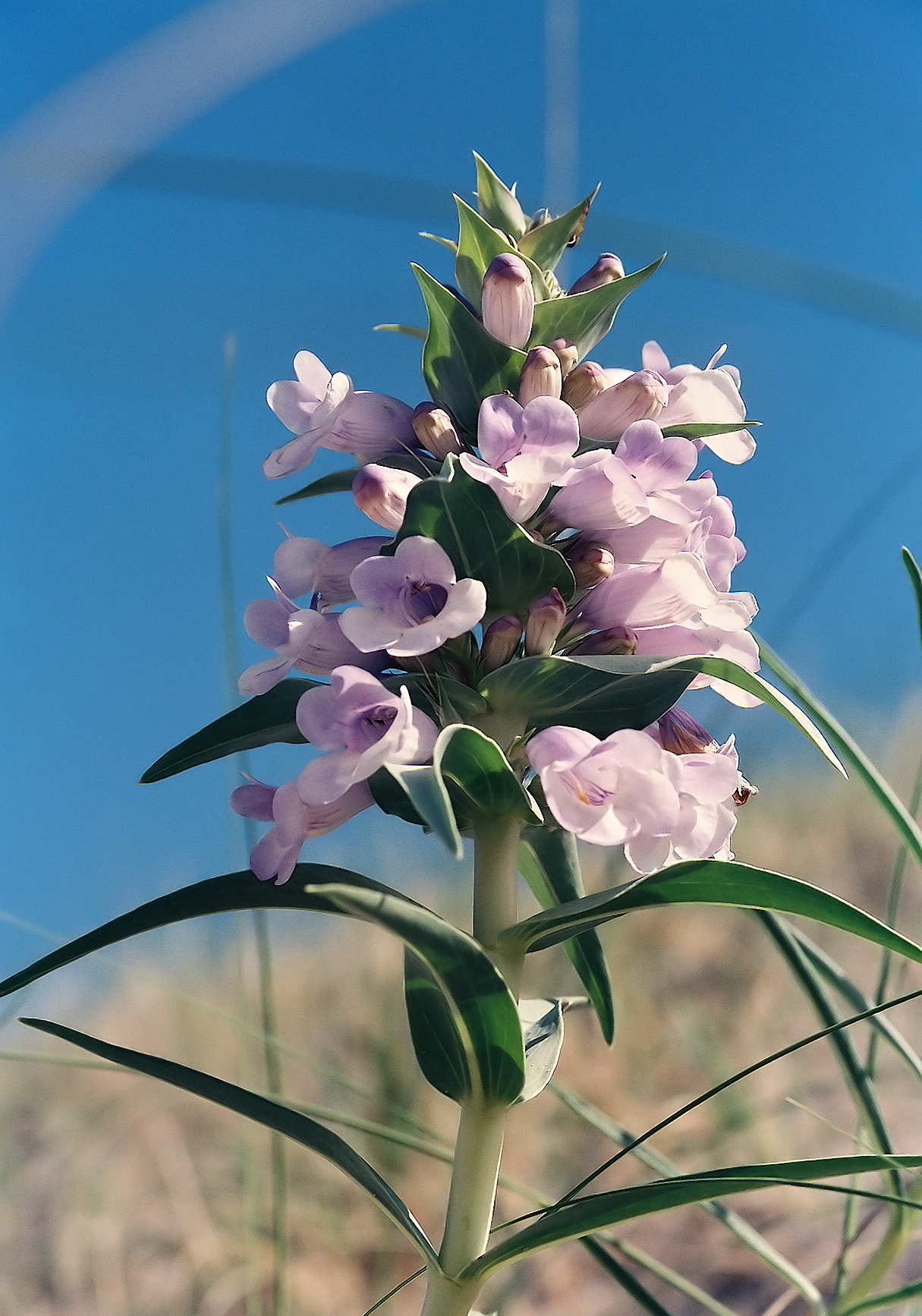
The flagship species of the Nebraska Sand Hills Mixed Grasslands ecoregion is the blowout penstemon. Image credit: Creative Commons
The mixed-grass prairie currently on the dunes is one of the most extensive in the U.S., and is dominated by sand bluestem, prairie sandreed, needle-and-thread grass, and little bluestem. With heavy grazing, the bluestems and needle-and-thread decline and hairy grama, prairie sandreed, and sand dropseed increase in cover. Blowouts in the sand dunes create open sand areas, some of which hold the ecoregion’s only endemic plant, the federal endangered blowout (Hayden’s) penstemon.
The 226-km2 Niobrara Valley Preserve (The Nature Conservancy) lies on the northern edge of the ecoregion along 40 km of the Niobrara River and has particularly diverse vegetation, including boreal forest, western coniferous forest, and eastern deciduous forest communities in addition to mixed-grass, tallgrass, and sandhills prairie. Biological surveys of the preserve identified 581 species of vascular plants, including ponderosa pine on the eastern limit of its range, a hybrid bigtooth-quaking aspen, and a disjunct population of paper birch.
Additional species at the preserve include 86 mosses, 80 lichens, 85 butterflies, and a reintroduced population of Plains Bison. Two lizard species studied in the Arapaho Prairie area of the ecoregion, the lesser earless lizard and eastern fence lizard, require open sand areas and decline with cessation of cattle grazing and increased vegetation cover.
Although only 2% of the ecoregion is currently protected, at least 57% of the area outside protected areas is in relatively natural condition, which is outstanding for the Great Plains. However, any increase in central-pivot irrigation in this ecoregion would constitute a serious threat, both due to its direct impact on native vegetation as well as its depletion of the Ogallala Aquifer.
Priority conservation actions for the next decade are to: 1) expand the existing protected areas in the ecoregion and acquire additional areas to better represent the full range of ecosystem types and provide enhanced connectivity among reserves; 2) improve management of existing conservation lands as well as private lands, for example by reducing stocking densities of cattle where appropriate; and 3) prohibit central-pivot and other irrigation throughout the ecoregion.
Citations
1. Sims, P.L., and P.G. Risser. 2000. Grasslands. Pages 323-356 in M.G. Barbour and W.D. Billings, eds. North American Terrestrial Vegetation, 2nd edition. Cambridge University Press, Cambridge, U.K.
2. Ricketts, T.H. et al. 1999. Terrestrial Ecoregions of North America: A Conservation Assessment. Island Press, Washington, D.C.
3. Whitcomb, R.F. 1989. Nebraska Sand Hills: the last prairie. Proceedings of the North American Prairie Conferences 33. http://digitalcommons.unl.edu/napcproceedings/33

Subscribe to receive monthly updates on climate solutions, environmental heroes, and the profound beauty and wonder of our shared planet Earth.
