

Tonle Sap Freshwater Swamp Forests
The ecoregion’s land area is provided in units of 1,000 hectares. The conservation target is the Global Safety Net (GSN1) area for the given ecoregion. The protection level indicates the percentage of the GSN goal that is currently protected on a scale of 0-10. N/A means data is not available at this time.
Bioregion: Indochina Mixed Forests & Peatlands (IM12)
Realm: Indomalaya
Ecoregion Size (1000 ha):
2,609
Ecoregion ID:
285
Conservation Target:
24%
Protection Level:
5
States: Cambodia, Vietnam
The ecological dynamics of this ecoregion are centered around the hydrological links between southeast Asia’s largest freshwater lake, the Tonle Sap, and the Mekong River. During the wet season, the water in the Mekong backs up into the Tonle Sap, inundating the floodplains with 4 to 6 m of water for over eight months. These wetlands and swamp forests then provide some of the most important bird habitats in the region, especially for huge numbers of gregarious waterbirds, such as storks, pelicans, ibises and cormorants. Seventeen Globally Threatened bird species can regularly be spotted around the lake.

The flagship species of the Tonle Sap Freshwater Swamp Forests ecoregion is the smooth-coated otter. Image credit: Creative Commons
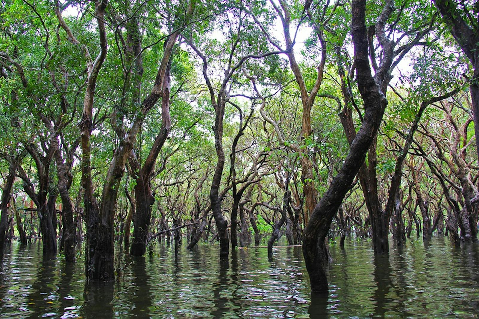
The Tonle Sap Freshwater Swamp Forests ecoregion extends south from Tonle Sap Lake in central Cambodia, along the Tonle Sap River, and then along the lower reaches of the Mekong River into southern Vietnam. The geological history of the lake is relatively recent, believed to have been formed due to the subsidence of the Cambodian platform about 5,700 years ago. The climate is tropical and seasonal. Mean temperatures can range between 20 and ºC, with the lowest temperatures in January and the hottest period in April. Average annual rainfall is about 1,300 to 1,561 mm, depending on location, and occurs mainly from April to November, with a peak in September.
The vegetation comprises of two forest associations: the swamp shrublands that cover most of the ecoregion and the stunted swamp forests around the lake itself. The structure and composition of woody vegetation is largely a function of the heterogeneity of soil moisture and seasonal flood dynamics. The dominant species form a nearly continuous canopy of deciduous species that barely reach 4 m in height.
The trees are dominated by species of Euphorbiaceae, Fabaceae, and Combretaceae. Common species include Barringtonia acutangula and Diospyros cambodiana, along with Coccoceras anisopodum, Crataeva nurvala, Crudia crysantha, Elaeocarpus griffithii, Garcinia loureiri, Lophopetalum fimbricatum, and Terminalia cambodiana. Woody climbers such as Acacia thailandica, Breynia rhamnoides, and Combretum trifoliatum add density to forest structure.

Sun bear. Image credit: J Patrick Fischer, Creative Commons
Some mammals of conservation significance include threatened species such as the pileated gibbon, wild dog, sun bear, clouded leopard, common leopard, banteng, smooth-coated otter, and hairy-nosed otter. But almost all of these species populations have been depleted due to hunting. The tiger is believed to be now extirpated, and Asian elephants that used to undertake seasonal migrations to the lake region no longer come there.
The swamp forests and bordering wetlands are very important habitat for birds, especially the waterfowl, among which are globally important populations of eastern sarus crane, white-shouldered ibis, and giant ibis. The greater flamingo was last recorded from the lake in 1935, and is now presumed to be locally extinct, even though there is suitable habitat for them.
Five species of turtles can be found in the lake and surrounding forests, but the mangrove terrapin is now believed to be extinct, although elderly residents say they were present in the 1990s. The Irrawaddy dolphin was decimated in the lake during the Khmer Rouge era when they were killed to make fuel oil.
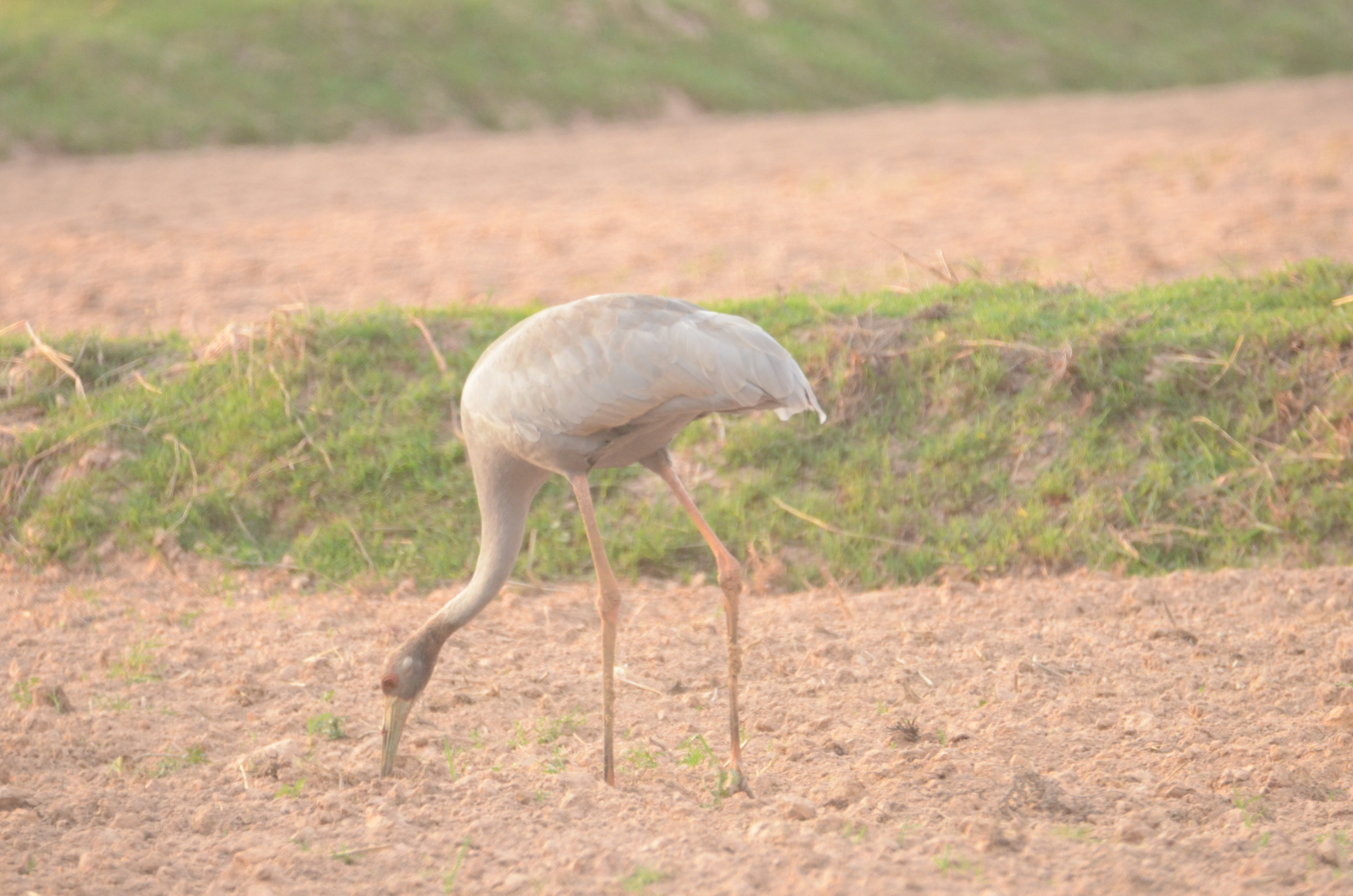
Eastern sarus crane. Image credit: Creative Commons
Only approximately 10% of the ecoregion’s forests still remain, but even these forests are heavily modified and degraded by farming, settlements, and extraction of timber and fuelwood.
Thus, the recommended priority conservation interventions are to: 1) secure the remaining habitats within protected areas, 2) provide effective protection and management for all protected areas, and 3) engage local stakeholders to shift away from unsustainable agriculture and extraction activities that would degrade the natural forests.
Citations
1. Campbell, I.C., Poole, C., Giesen, W. and Valbo-Jorgensen, J., 2006. Species diversity and ecology of Tonle Sap Great Lake, Cambodia. Aquatic Sciences, 68(3), pp.355-373
2. Wikramanayake, E, E. Dinerstein, et al. 2002. Terrestrial Ecoregions of the Indo-Pacific: A Conservation Assessment. Island Press.
3. Critical Ecosystems Partnership Fund. 2012. Ecosystem Profile. Indo-Burma Biodiversity Hotspot. 2011 Update. https://www.cepf.net/Documents/final.indoburma_indochina.ep.pdf Accessed Dec 2017.

Subscribe to receive monthly updates on climate solutions, environmental heroes, and the profound beauty and wonder of our shared planet Earth.
