
Canadian Low Arctic Tundra
The ecoregion’s land area is provided in units of 1,000 hectares. The protection goal is the Global Safety Net (GSN1) area for the given ecoregion. The protection level indicates the percentage of the GSN goal that is currently protected on a scale of 0-10.
Bioregion: Canadian Tundra (NA2)
Realm: Subarctic America
Ecoregion Size (1000 ha):
83,727
Ecoregion ID:
413
Conservation Target:
97%
Protection Level:
2
States: Canada: NT, NU, QC
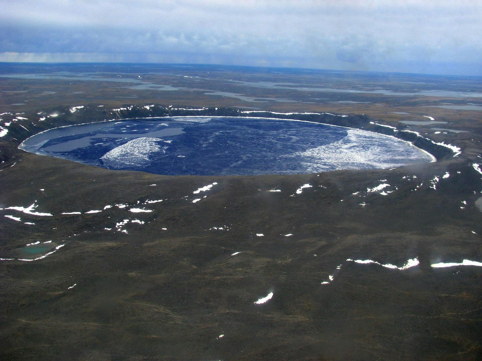
The Canadian Low Arctic Tundra ecoregion is the largest ecoregion in Northern America Realm. It stretches as a continuous swath across northern Northwest Territories and Nunavut to Hudson Bay, occurs on several islands in Hudson Bay, and then again on the east side of Hudson Bay on the Ungava Peninsula in northern Quebec. Most of the ecoregion is rolling uplands and lowlands underlain by Precambrian granitic bedrock, which is often exposed. Eskers, sinuous ridges formed by streams running in ice tunnels beneath glaciers and depositing gravel, are common, with some up to 100 km in length. Lakes, ponds, and wetlands are abundant across the landscape.
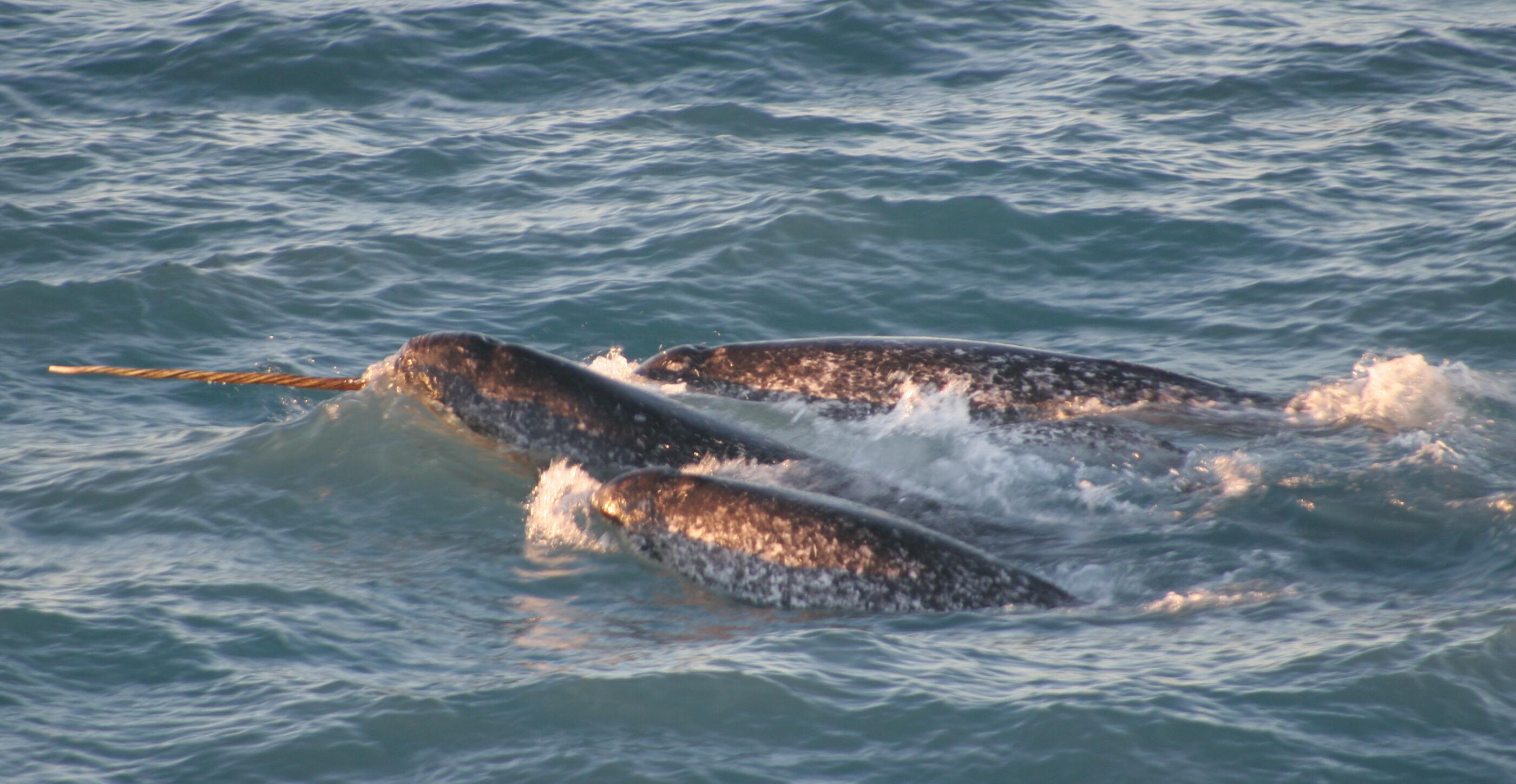
The flagship species of the Canadian Low Arctic Tundra ecoregion is the narwhal. Image credit: Creative Commons
Approximately 97% of the ecoregion is intact, but only 13% is protected; the remaining 84% natural habitat outside protected areas offers abundant opportunities for conservation. Major protected areas, which could be expanded, include Tuktut Nogait National Park in Northwest Territories, Pingualuit National Park in Quebec, and a number of bird sanctuaries in Northwest Territories and Nunavut, including Queen Maud Gulf Migratory Bird Sanctuary, at 61,765 km2 the largest federal protected area in Canada.
The climate of this ecoregion is predominantly low Arctic, characterized by short, cool summers and long, very cold winters. Mean summer temperatures range from 4ºC to 6ºC. Average winter temperatures range from -28ºC in the northwest to -17.5ºC in the southeast. Permafrost is mostly continuous with active layers that are often wet or moist throughout the summer. Discontinuous permafrost occurs on the Ottawa Islands and Belcher Islands in Hudson Bay.
Average annual precipitation varies widely across the ecoregion, from 200 mm in the northwest along the Amundsen Gulf coast to 500 mm in the Ungava Peninsula of Quebec. Islands in the Coronation Gulf and Hudson Bay often experience local weather conditions of drizzly, foggy weather in late summer and early fall due to the moderating effect of open water.
The vegetation of the ecoregion is predominantly shrubby tundra with abundant dwarf birch. Some tundra-subarctic taiga transitional vegetation occurs, featuring black spruce, white spruce, tamarack, dwarf birch, and plants in the heath family. Spruce forest occurs in some major river valleys.
This ecoregion is especially important for birds and mammals. In particular, it encompasses the major summer range and calving grounds of some of Canada’s largest caribou herds, with barren-ground caribou in the west and woodland caribou in the east. The herds collectively totaled around 1.5 million animals in the 1990s. Four of those herds have declined by 84–93% since then, and a 2018 survey revealed a total population of about 157,500 animals.
This ecoregion is also significant for containing the largest mainland population of musk ox. Other characteristic mammals include grizzly bear (in the west), black bear (in Quebec), polar bear (in coastal areas), wolf, moose, Arctic ground squirrel, collared lemming, and brown lemming. Marine mammals include walrus, several species of seals, beluga whale, and narwhal.
Representative birds include loons (yellow-billed, red-throated, and Arctic), tundra swan, snow goose, Ross’s goose (with a majority of the world population nesting in Queen Maud Gulf Migratory Bird Sanctuaryi), long-tailed duck, gyrfalcon, willow and rock ptarmigan, red-necked phalarope, parasitic jaeger, snowy owl, hoary redpoll, and snow bunting.
Although this region is largely intact, its poor protection status is a cause for concern. Mining, especially of diamonds and copper, and associated roads are significant threats. Priority conservation actions for the next decade are: 1) greatly expand the network of protected areas across the ecoregion; 2) prohibit incompatible uses, including mining and intensive recreation, within designated protected areas; and 3) protect vulnerable species such as caribou and muskox from over-harvest and by securing their migration routes.
Citations
1. Ricketts, T.H. et al. 1999. Terrestrial Ecoregions of North America: A Conservation Assessment. Island Press, Washington, D.C.
2. Ecological Stratification Working Group. 1995. A National Ecological Framework for Canada. Environment Canada and other agencies, Ottawa.
3. Tuktut Nogait National Park. https://en.wikipedia.org/wiki/Tuktut_Nogait_National_Park

Subscribe to receive monthly updates on climate solutions, environmental heroes, and the profound beauty and wonder of our shared planet Earth.
