

Inner Niger Delta Flooded Savanna
The ecoregion’s land area is provided in units of 1,000 hectares. The protection goal is the Global Safety Net (GSN1) area for the given ecoregion. The protection level indicates the percentage of the GSN goal that is currently protected on a scale of 0-10.
Bioregion: Sahel Acacia Savannas (AT23)
Realm: Afrotropics
Ecoregion Size (1000 ha):
4,613
Ecoregion ID:
71
Conservation Target:
51%
Protection Level:
10
States: Mali
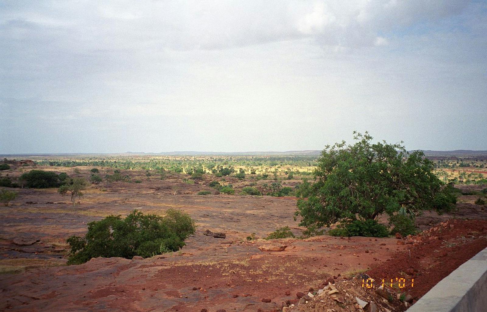
The Inner Niger Delta Flooded Savanna is the largest inland wetland in West Africa and the second largest in Africa after the Okavanga Delta in Botswana. This vast floodplain, situated in the middle of the Sahelian landscape, expands to 30,000 km2 during the flood season when the Niger and Bani rivers spill over their banks and contracts to 3,900 km2 during the dry season. More than one million wetland-related birds, in particular sand martin and yellow wagtail, use the delta.
The ecoregion contains the inland delta of the Niger River in central Mali between Djenné in the south and Tombouctou in the north. The floodplain is remarkably level, dropping only 8 m over its course. The local rainfall over the delta varies from 750 mm to 250 mm, but has a negligible impact on the flooding. The floodwaters come primarily from the Niger River, its main tributary the Bani River, and much smaller and temporal streams that flow down from the Dogonland Plateau. Rains fall on the Niger’s headwaters in the Fouta Djalon highlands of Guinea from May through September, creating a flood surge that reaches the inland delta in October. The flooding extension varies from year to year.
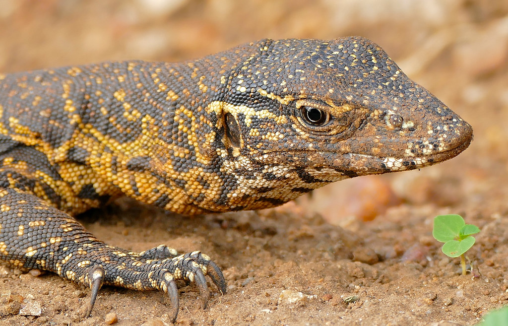
The flagship species of the Inner Niger Delta Flooded Savanna ecoregion is the Nile monitor. Image credit: Courtesy of Bernard Dupont, Flickr
A diverse mix of vegetation occupies the wetland. Flooded forests dominated by Acacia kirkii with some Ziziphus mauritiana form a characteristic, but dwindling, type of vegetation in the area. Trees such as Diospyros spp. and Kigelia africana grow on higher levees, whereas palms such as Hyphaene thebaica and Borassus aethiopum occur near villages.
The delta provides essential habitat for huge numbers of wetland birds, including Afrotropical resident species and Palearctic migrants. More than 500,000 garganey and up to 200,000 northern pintail use the delta during the northern winter, along with large numbers of ferruginous duck, white-winged tern, ruff, black-tailed godwit, and other waterbirds. Total bird numbers can reach over one million in suitably wet years.
The delta supports two of the largest known breeding colonies of herons and cormorants in Africa. Breeding occurs during the high flood season (September–November) and the colonies are situated in flooded forests of mainly Acacia kirkii.
Mammal species include warthog, Saharan striped polecat, side-striped jackal, patas monkey, pale fox, and African wild cat. A small population of elephants lives east of the delta, and migrates between Burkina Faso and southern Mali. The delta also harbours an important but dwindling population of west African manatees. Hippos are present but the population is reduced to only 40-60 individuals.
The vast floodplains also provide habitat for Nile crocodile, Nile monitor, and African rock python. Nile crocodile is believed to be on the edge of extinction, while the Nile monitor and rock python are facing heavy human pressure.
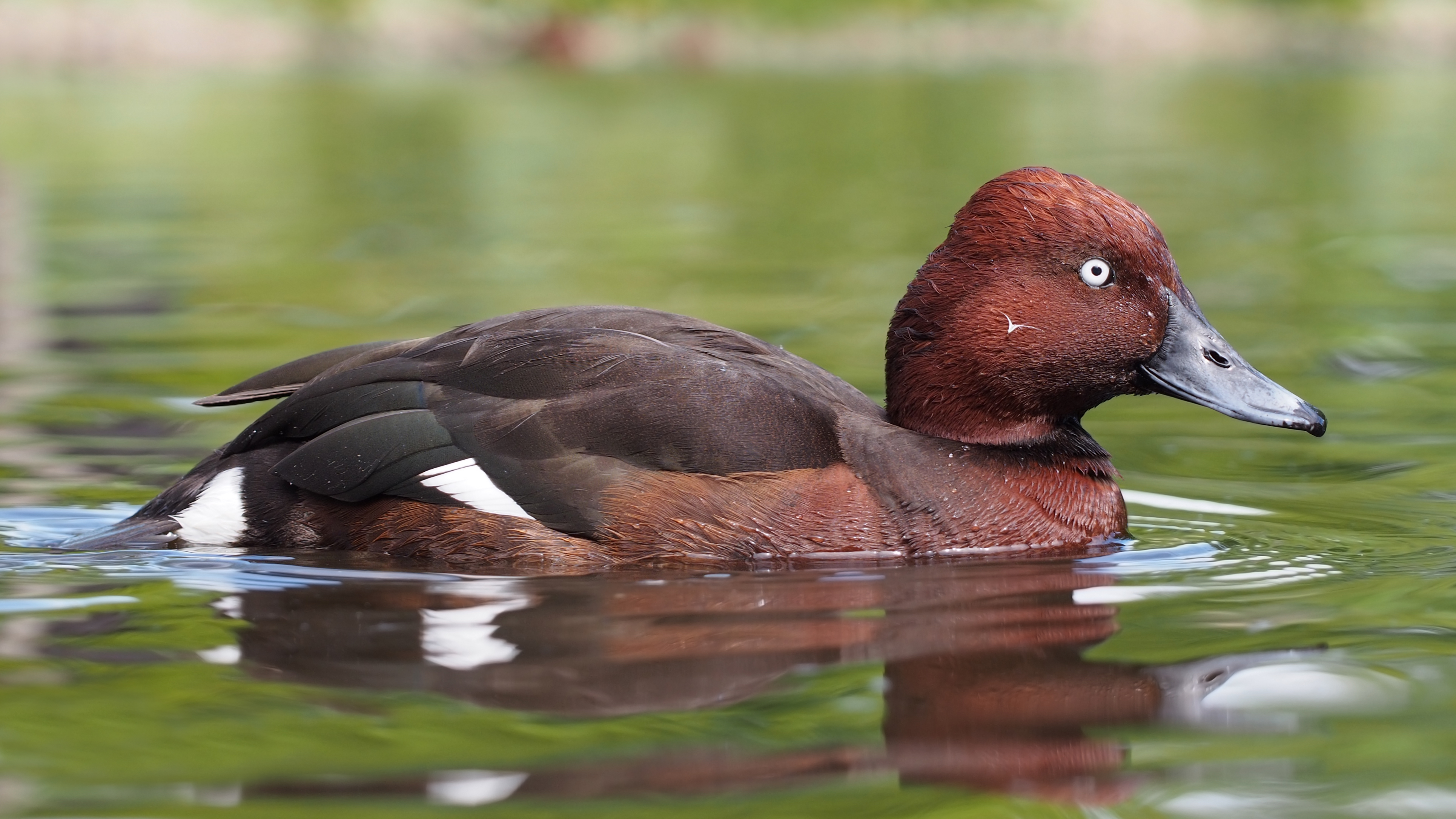
Ferruginous duck. Image credit: Francis Franklin, Creative Commons
Three Ramsar sites were declared in 1987: Lac Horo, Lac Débo, and the Séri floodplain complex, together comprising 1,620 km2. In 2004, they were replaced with the Delta interieur du Niger which covers 41,195 km2. The Ramsar site is owned by the state and utilized by local residents and nomadic pastoralists for drinking water, fishing, seasonal agriculture, and livestock rearing. Lac Horo is separated from the Niger by a dam and a sluice gate. The rest of the area is unprotected and under intense pressure from human activities.
People have intensively exploited the Niger Delta over the last 1,000 years and today, approximately 2 million people depend on the delta for their livelihoods. Farming varies from subsistence level to larger, irrigated projects. Hydro dams have been established (Selingue dam in 1981, and smaller dams such as Markala) to supply water during drought periods and to generate power for cities. However, they reduce the inundated flood reach.
The annual floods are important for humans and the ecology: breeding waterbirds use the flooded grasslands as their breeding habitat, juvenile fish use it as their nursery ground and pastoralists rely on the exceptionally fertile flooded pasture for their cattle to feed on.
Additionally, rice farmers move their production to lower elevations during periods of low flooding, usually encroaching on bourgeou pastures. This deprives cattle of passage ways and food when they are back in the delta in December leading to conflict between herders and rice farmers. The proposed installation of further water management projects, for example the Fomi Dam, would further increase food insecurity and put breeding colonies at rise of extinction.
The priority conservation actions for the next decade will be to: 1) encourage prioritisation of crops that are less water intensive than sugar; 2) scale up flood prediction tools; and 3) establish alternative energy sources, for example solar power.
Citations
1. Burgess, N., Hales, J.A., Underwood, E., Dinerstein, E., Olson, D., Itoua, I., Schipper, J., Ricketts, T. and Newman, K. 2004. Terrestrial ecoregions of Africa and Madagascar: a conservation assessment. Island Press.
2. Morand,P., Sinaba, F. and Niang-Fall, A. 2016. Fishermen, Herders and Rice-Farmers of the Inner Niger Delta Facing the Huge Challenge of Adapting to Weakened Floods: A Social- Ecological System at Risk. In: Tvedt, T. and Oestigaard, T. ed. A History of Water. Series III. Vol. 3: Water and Food. London: Taurus, pp. 418-436
3. Wymenga, E., Zwarts, L. and Kone, B. 2012. Water sharing in the Upper Niger Basin. A&W-rapport 1739. Mali: Wetlands International & Feanwâlden, Netherlands: Altenburg & Wymenga ecological consultants.
4. Zwarts, L., van Beukering, P., Kone, B. and Wymenga, E. 2005. The Niger, a lifeline. Effective Water Management in the Upper Niger Basin. RIZA, Lelystad.

Subscribe to receive monthly updates on climate solutions, environmental heroes, and the profound beauty and wonder of our shared planet Earth.
