

Lake Chad Flooded Savanna
The ecoregion’s land area is provided in units of 1,000 hectares. The protection goal is the Global Safety Net (GSN1) area for the given ecoregion. The protection level indicates the percentage of the GSN goal that is currently protected on a scale of 0-10.
Bioregion: Sahel Acacia Savannas (AT23)
Realm: Afrotropics
Ecoregion Size (1000 ha):
3,218
Ecoregion ID:
72
Conservation Target:
65%
Protection Level:
9
States: Cameroon, Chad, Niger, Nigeria
Lake Chad’s volume decreased dramatically by 95 percent between 1963 and 2008. The lake is a vital refuge to migrating birds, especially ducks and waders that spend the northern European winter period in Africa. Additionally, more than 30 million inhabitants are dependent on the lake’s resources. Despite the high rates of evaporation at 2,300 mm per year, Lake Chad has low levels of salinity because the more saline waters sink and exit the lake through subterranean conduits in the north.
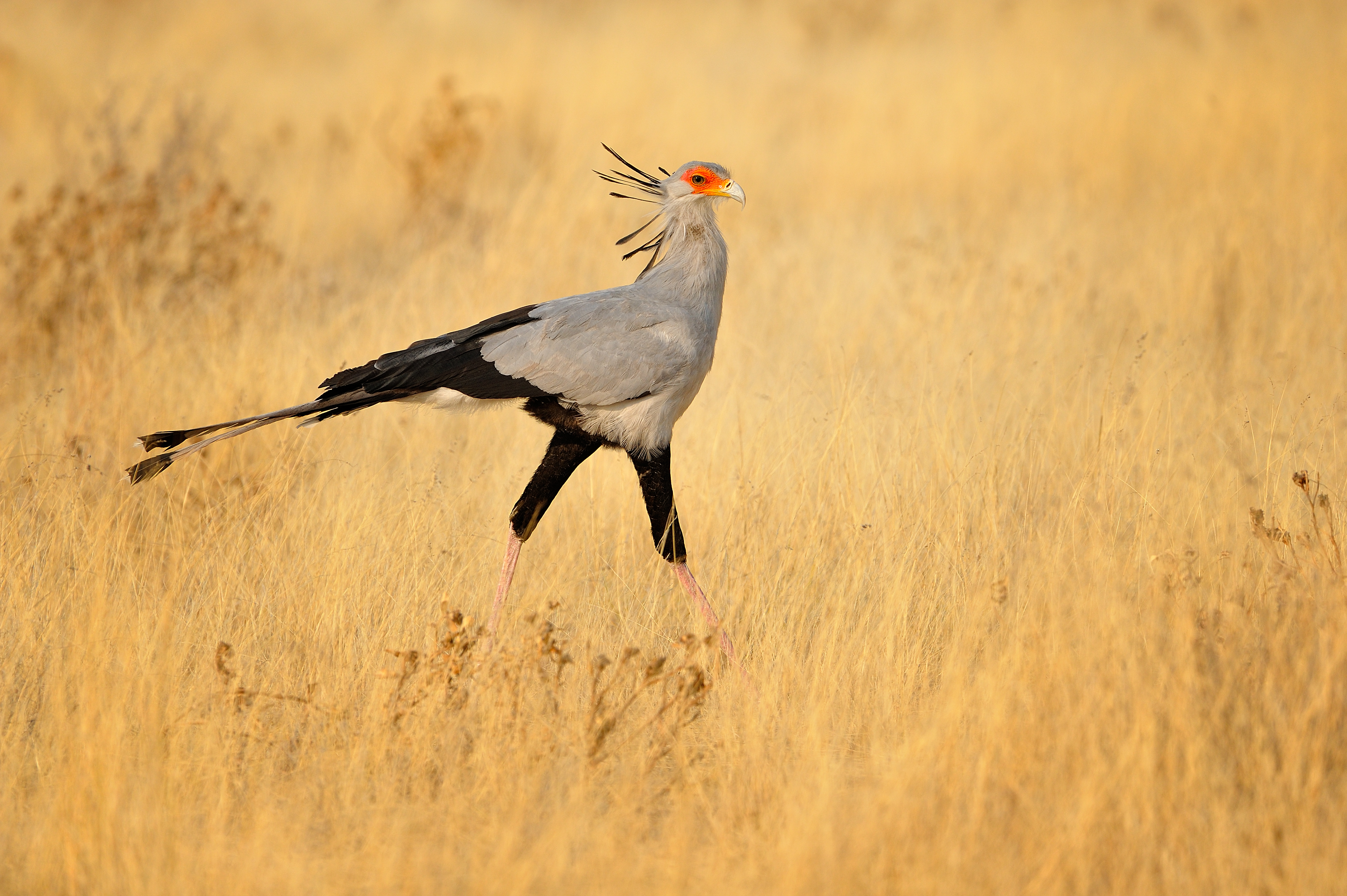
The flagship species of the Lake Chad Flooded Savanna ecoregion is the secretary bird. Image credit: Courtesy of Wildscreen Exchange
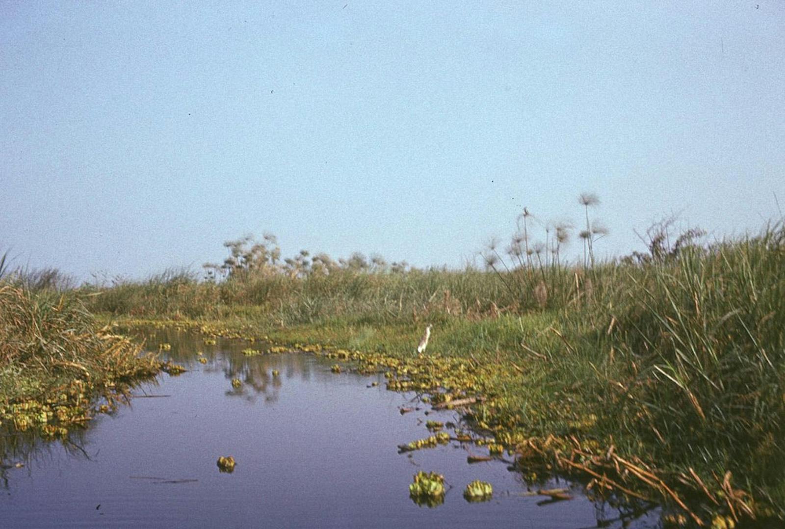
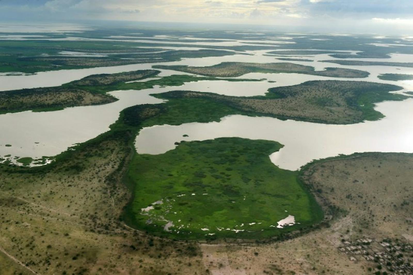
The ecoregion includes Lake Chad and the nearby Hadejia-Nguru wetlands. Lake Chad straddles the borders between four African countries: Cameroon, Chad, Niger, and Nigeria. The lakes surface area fluctuates greatly by season and by year with changing rainfall patterns associated with oscillations in the Intertropical Convergence Zone (ITCZ). The lake shrunk from 25,000 km2 in the 1960s, to one-tenth of that size by the mid-1980s. Since then the lake has seen some recovery and the average total monthly surface water area for the dry season from 1989 to 2017 was 12,700 km2.
An outlier of the ecoregion is found at the Hadejia-Nguru floodplain in northern Nigeria which is connected to Lake Chad by the Yobe River. The climate is dry, with an annual average rainfall of 320 mm, with most occurring between June and October. Most water input comes from rivers, with the majority of input originating as precipitation and brought to Lake Chad via the Chari and Logone Rivers. During wetter periods of the Pleistocene the lake expanded to cover 2.5 million km2.
_CC-Olaf%20Olivero%20Riemer-2012.jpg)
Black crowned crane. Image credit: Olaf Olivero Riemer, Creative Commons
Vegetation in the south basin of Lake Chat consists of Cyperus papyrus, Phragmites mauritianus, Vossia cuspidata, and other wetland plants. Phragmites australis and Typha australis grow in the more saline north basin. Occasionally, the floating plant Nile lettuce covers large areas of open water. Seasonal yaére grassland grow on the southern lakeshore, where annual flooding is prolonged and water depth reaches 2 m. Vegetation consists of Echinochloa pyramidalis, Vetiveria nigritana, Oryza longistaminata, and Hyparrhenia rufa.
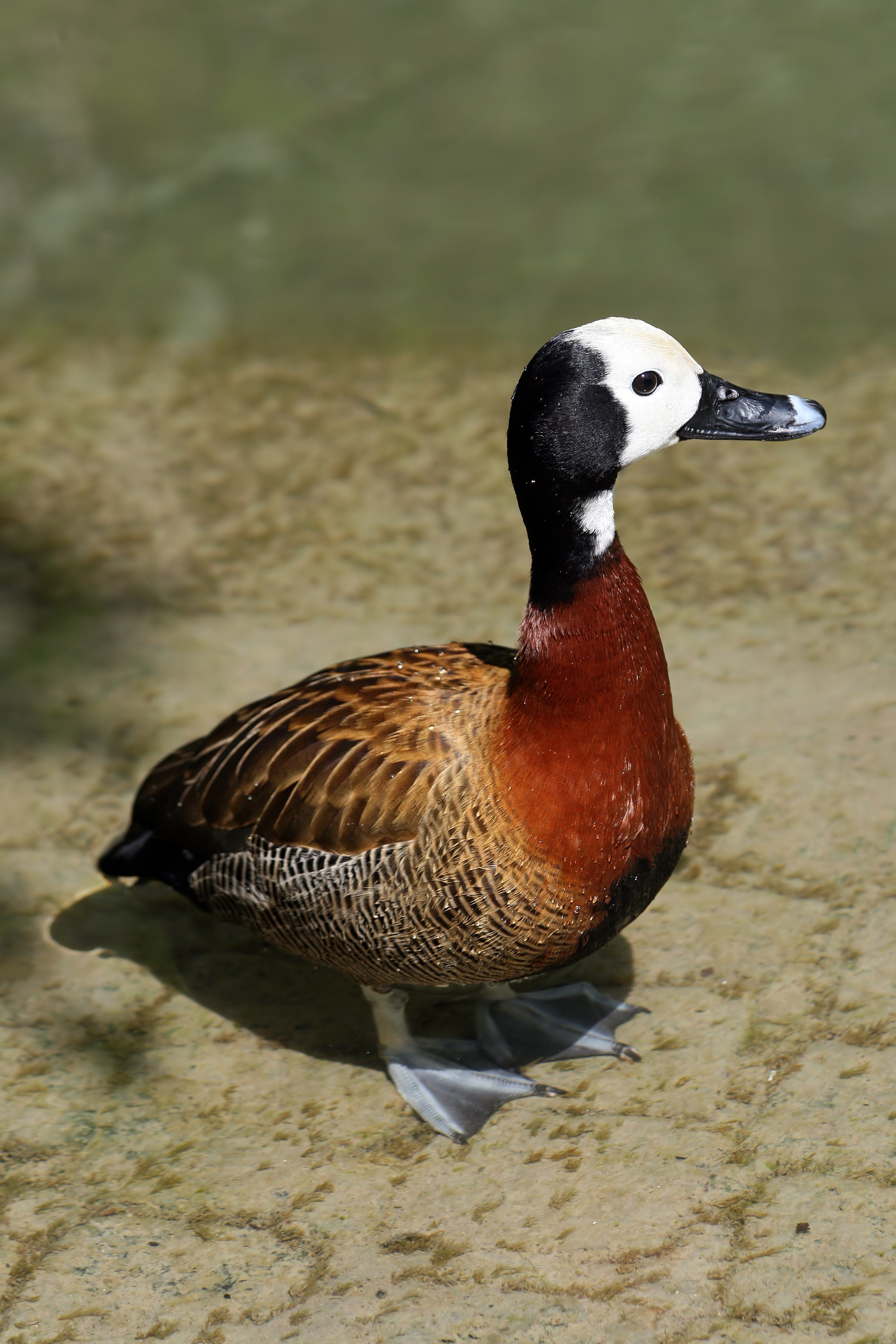
Dendrocygna viduata. Image credit: Richard Bartz, Creative Commons
This ecoregion is important for large numbers of migrant birds. Seventeen species of waterfowl and 49 other wetland bird species are recorded, with abundance varying from year to year. More than one million ruff have been recorded at Lake Chad. In the Hadejia-Nguru wetlands the most common waterbirds are white-faced whistling duck, garganey, northern pintail, and ruff. Lake Chad supports two near-endemic bird species, the river prinia, and the more widespread rusty lark.
The lakeshore is also important for large concentrations of Palearctic birds of prey, such as the steppe eagle and booted eagle. Two near-endemic rodent species are found, Mastomys verheyeni and the Lake Chad gerbil. The wetlands of Lake Chad and Hadejia-Nguru formerly supported herds of large mammals. Savanna species included red-fronted gazelle, dama gazelle, patas monkey, striped hyena, cheetah, and caracal.
Species more adapted to the wetland habitats included African elephant, two species of otter, hippopotamus, sitatunga, and kob. Most of the large mammals have been hunted out, and replaced by large numbers of cattle. Nile crocodiles are also now extremely rare and may have been wiped out. Large numbers of fish, corresponding with seasonal inflows, migrate to the rich floodplains to feed and breed. Many of these species also occur in the Nile, Niger, and Zaire Rivers.
 with a cattle egret (Bubulcus ibis) in Chobe National Park, Botswana. Image credit: Diego Delso, Creative Commons.")
Hippo. Image credit: Diego Delso, Creative Commons
Local communities occupy most of the land for settlements, farms, cattle grazing, and as bases for fishing. Part of the area is found within the Chad Basin National Park. In Nigeria and Cameroon, the Lake Chad Ramsar Site was established (covering a total area of 8,225 km2). The outlier in Nigeria is partly protected by Rurum Forest Reserve and Falgore Game Reserve. The Lake Chad Basin Commission was formed in 1964 to regulate and plan uses of the water and natural resources within the Lake Chad Basin.
Severe drought through the 1970s devastated the Sahelian region, and led to decreased water inflows into Lake Chad and a decrease in the lakes volume by 95% from 1963 to 2008. During the drought, increased human pressure on the dwindling lake and surrounding habitats put intense pressure on the entire area. In recent years the rains have been better and the lake has increased in area, however, the variability of the hydrological regime and availability of freshwater is still a major threat. The extent of local irrigation also increased after the introduction of small gasoline-powered pumps.
The fish populations in the lake have suffered declines recently from drought, overfishing, diversion or blockage of instream flows, and increased juvenile catch due to the use of smaller mesh. The most economically important fish in Lake Chad are the characin and the Nile perch. Characin populations have decreased drastically while Nile perch catch-sizes have decreased substantially. Additionally, leaching of agro-chemicals is polluting the wetland system.
The priority conservation actions for the next decade will be to: 1) support the implementation of good fishing practices and fish stock conservation; 2) implement afforestation and reforestation schemes within the basin; and 3) support and strengthen the capacity of Integrated Water Resources Management (IWRM) in the ecoregion to better manage the water resources of the basin.
Citations
1. Burgess, N., Hales, J.A., Underwood, E., Dinerstein, E., Olson, D., Itoua, I., Schipper, J., Ricketts, T. and Newman, K. 2004. Terrestrial ecoregions of Africa and Madagascar: a conservation assessment. Island Press.
2. Lake Chad Basin Commission. 2016. The Lake Chad Development and Climate Resilience Action Plan. Washington DC, USA: World Bank.
3. FAO. 2008. The Lake Chad Basin: a system under threat. [Online]. [Accessed 6 February 2018]. Available from: http://www.fao.org/docrep/014/i2345e/i2345e06.pdf
4. Policelli, F., Hubbard, A., Jung, H.C., Zaitchik, B. and Ichoku, C. 2018. Lake Chad Total Surface Water Area as Derived from Land Surface Temperature and Radar Remote Sensing Data. Remote Sensing. 10(2), p.252.

Subscribe to receive monthly updates on climate solutions, environmental heroes, and the profound beauty and wonder of our shared planet Earth.
