

Rwenzori-Virunga Montane Moorlands
The ecoregion’s land area is provided in units of 1,000 hectares. The conservation target is the Global Safety Net (GSN1) area for the given ecoregion. The protection level indicates the percentage of the GSN goal that is currently protected on a scale of 0-10. N/A means data is not available at this time.
Bioregion: Victoria Basin & Albertine Rift Forests (AT12)
Realm: Afrotropics
Ecoregion Size (1000 ha):
52
Ecoregion ID:
86
Conservation Target:
100%
Protection Level:
10
States: Democratic Republic of Congo, Uganda, Rwanda
The ‘Mountains of the Moon’, otherwise known as the Rwenzori mountain range, extends up to 5,108 m at the Margherita summit, Africa’s third tallest peak after Mount Kilimanjaro and Mount Kenya. Years of violence and conflict on the Democratic Republic of the Congo side of range mean that tourists have been few and far between. Since the end of the worst aspects of the turmoil, the allure of mountain gorilla has attracted an increasing number of tourists to these mountains, and walkers are also returning to the high mountain trails of these moorlands.
The moorlands occupy the high elevation (above 3,000 m) portions of the Rwenzori and Virunga Mountains. The Rwenzori range is located along the borders of southwestern Uganda and the Democratic Republic of Congo (DRC), and the Virungas at the borders of Rwanda, DRC, and Uganda.
Topographically, this is an extremely rugged area. The Rwenzori Mountains differ from the other high mountains in East Africa because they are made up of Precambrian basement rocks uplifted in the middle Tertiary and are not volcanic in origin. The highest parts of the Rwenzori contain snowfields and glaciers, although these are retreating.
.jpg)
The flagship species of the Rwenzori-Virunga Montane Moorlands ecoregion is the Rwenzori black-fronted duiker. Image credit: Courtesy of Simone Jacopino, iNaturalist
The extreme climate of this ecoregion is governed by its close proximity to the equator and the high altitude. On most days the night time temperatures dip below freezing and then rise above freezing during the daytime. However, the temperature fluctuations are not as severe as in the other montane regions in eastern Africa, largely because of the more frequent cloud cover.
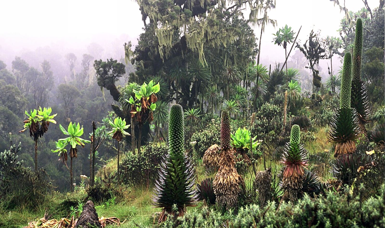
Seven main vegetation formations are recognized: ericaceous woodland and wooded grassland with Philippia and Erica arborea, Dendrosenecio woodland and wooded grassland, tussock grassland, Helichrysum scrub, and swamp or mire vegetation. Hagenia-Hypericum woodland occurs on the more humid slopes in the south and west of Volcanoes Ntaional Park between 2,600 and 3,600 m elevation.
This ecoregion forms part of the Afroalpine archipelago-like region of extreme floristic impoverishment, but with high rates of endemism. Endemic species in this region may have evolved due to glacial cycles that compressed these montane populations and then expanded allowing speciation to occur. Most impressive are the giant heathers, groundsels, ericas, and lobelias adapted to these harsh climatic conditions, some of which are endemic. Fourteen plant species are strictly endemic to the Rwenzoris and five to the Virungas in the Afromontane and altimontane zones.
This ecoregion also supports endemic and near-endemic bird species. The endemic Stuhlmann’s double-collared sunbird confined to high (2,600–3,500 m) elevations in the Rwenzori Mountains. The majority of the near-endemic species use several mountains along the Albertine Rift chain, and range over a variety of elevations. These birds include Rockefeller’s sunbird, Archer’s robin-chat, handsome francolin, and stripe-breasted tit.
Larger mammals tend to be visitors and are often opportunists and/or generalists. The exception to this is the Rwenzori black-fronted duiker, whose distribution is confined to the Rwenzori Mountains and is shared between this ecoregion and the lower elevation Albertine Rift Montane Forests. The mountain gorilla occasionally uses the border habitat with the moorlands and the montane forests. Larger mammals that regularly move between lowland or montane forests and this region include elephant, buffalo, leopard, African golden cat, and side-striped jackal.
As the habitats are at extremely high altitudes, there has been little fragmentation or habitat degradation from human use. The entire ecoregion is protected within several national parks: Mgahinga Gorilla (38 km2) and Rwenzori Mountains National Parks (996 km2) in Uganda, Volcanoes National Park (160 km2) in Rwanda, and Virunga National Park (8,091 km2) in DRC. These areas also hold additional status as either World Heritage sites or biosphere reserves.
Few people live within this ecoregion as it falls within national parks, although population densities are increasing outside the parks, especially in Rwanda. The large mammal fauna is threatened by hunting for meat, and for use as fetishes by the local population. Most hunting in Uganda and Rwanda is through snares, whereas in DRC guns are used more commonly.
Current problems include encroachment, illegal wood and bamboo cutting, feral dogs, increased agricultural and pastoral activities on park borders, reduced occult precipitation, and the invasion of exotic plant species such as black wattle. An additional threat includes human-induced fire to clear land for agriculture which has depressed the forest border. However, despite all these threats, gorilla numbers are increasing and tourists are returning to the ecoregion providing alternative livelihood opportunities including ecotourism.
The priority conservation actions for the next decade will be to: 1) promote community conservation enterprises, for example, cultural villages, craft shops, and guest houses to allow communities to reap benefits from tourism and reduce dependency on natural resources; 2) improve law enforcement across borders and coordinate patrolling and transboundary collaboration; and 3) re-initiate sustainable and responsible ecotourism in the high moorlands to support local communities and conservation work.
Citations
1. Burgess, N., Hales, J.A., Underwood, E., Dinerstein, E., Olson, D., Itoua, I., Schipper, J., Ricketts, T. and Newman, K. 2004. Terrestrial ecoregions of Africa and Madagascar: a conservation assessment. Island Press.
2. CEPF. 2012. Ecosystem profile: Eastern Afromontane biodiversity hotspot. [Online]. [Accessed 12 March 2018]. Available from: https://www.cepf.net/sites/default/files/eastern_afromontane_ecosystem_profile_final.pdf
3. Eggermont, H., Van Damme, K. and Russell, J.M. 2009. Rwenzori mountains (mountains of the moon): headwaters of the white Nile. In The Nile (pp. 243-261). Dordrecht: Springer.
4. Plumptre, A.J., Kujirakwinja, D., Treves, A., Owiunji, I. and Rainer, H. 2007. Transboundary conservation in the greater Virunga landscape: its importance for landscape species. Biological conservation. 134(2), pp.279-287.

Subscribe to receive monthly updates on climate solutions, environmental heroes, and the profound beauty and wonder of our shared planet Earth.
