
Torngat Mountain Tundra
The ecoregion’s land area is provided in units of 1,000 hectares. The protection goal is the Global Safety Net (GSN1) area for the given ecoregion. The protection level indicates the percentage of the GSN goal that is currently protected on a scale of 0-10.
Bioregion: Canadian Tundra (NA2)
Realm: Subarctic America
Ecoregion Size (1000 ha):
3,267
Ecoregion ID:
421
Conservation Target:
95%
Protection Level:
4
States: Canada: NL, QC
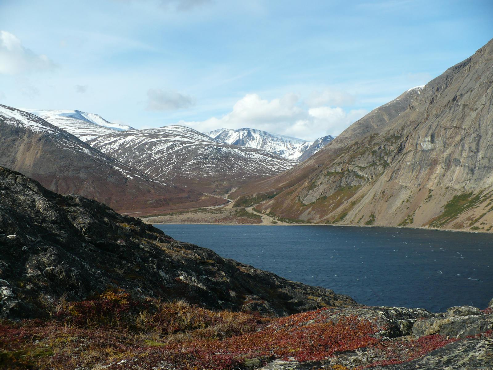
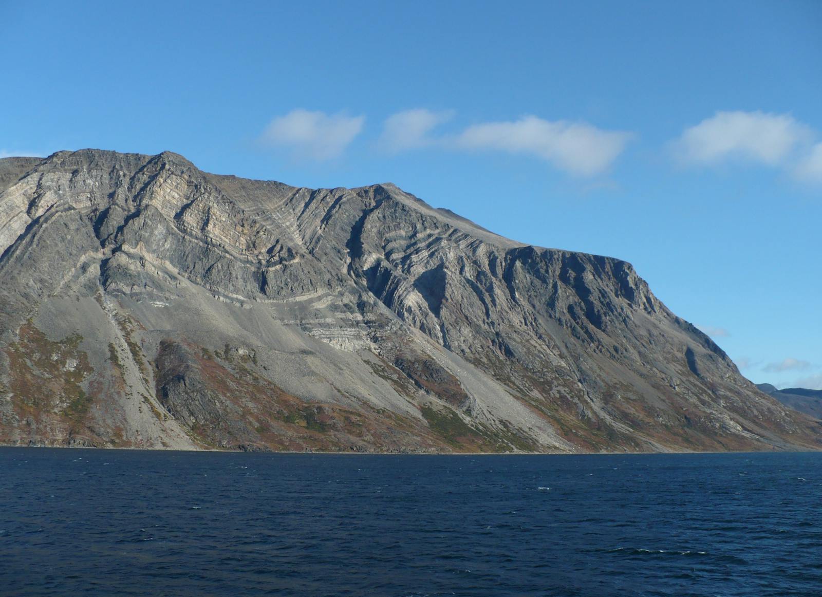
The Torngat Mountain Tundra ecoregion is a relatively small ecoregion occupying far northern Labrador and the western slopes of the Torngat Mountains in northeastern Quebec. This peninsular ecoregion lies to the north of the Eastern Canadian Shield Taiga ecoregion and projects into the sea where the Atlantic Ocean (Labrador Sea) meets the Arctic Ocean (Ungava Bay). This is a mountainous Arctic ecoregion, which mingles with the boreal forest in its southern portion, especially in low valleys and river corridors.
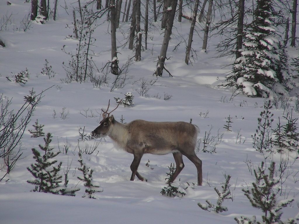
The flagship species of the Torngat Mountain Tundra ecoregion is the Torngat caribou. Image credit: Creative Commons
The highest peak in the Torngat Mountains is Mount Caubvick, at 1,652 m elevation. The mountains are composed of pre-Cambrian (Archaean) granitic bedrock and are rounded and steep-sided, with deeply incised valleys as well as glacier-carved, U-shaped valleys and fjords along the coast of the Labrador Sea.
The climate of this ecoregion is moist low Arctic, which is characterized by humid and cold conditions over most of the year. Summers are cool and moist, with a mean temperature of 4ºC, and winters are long and cold, with a mean temperature of -16.5ºC. The mean annual temperature is approximately -6.5ºC. Permafrost is continuous, with ice wedges, in the western portion of the ecoregion but is less extensive and discontinuous in the eastern, coastal portion. The average annual precipitation ranges from 400 mm to 700 mm, with higher levels at high-central elevations.
The dominant vegetation of the ecoregion is Arctic heath tundra with a sparse cover of lichen, moss, Arctic sedge, and grasses. Unvegetated rock is abundant, and patches of mixed evergreen and deciduous shrubs occur on sheltered, south-facing slopes. Thickets of paper birch and willow grow on less stable scree slopes and often form a transition zone between tundra and open forests of black spruce. Black spruce, shrubs, and mosses dominate wetter sites.
Both polar bear (the southernmost denning population on the east coast of North America) and the only tundra-dwelling population of black bear in the world inhabit this ecoregion. Also of high importance for conservation is the Torngat caribou herd, whose annual range lies entirely within this ecoregion. These caribou do not undertake long migrations, but rather make relatively short-distance movements between their winter range and calving sites. This herd has declined significantly over recent decades and numbered only 1,426 animals in 2018. The decline is related to a low survival rate of adult females due to a combination of subsistence hunting and predation by wolves.i
Other vertebrates of note in the ecoregion include Arctic fox, spruce grouse, willow ptarmigan, Arctic char, brook trout, whitefish, and Atlantic salmon.
Approximately 98% of the ecoregion is intact, including 40% within protected areas and 58% outside protected areas. Reversing that ratio through new designations would be a prudent course of action. The two major existing protected areas, which could be expanded, are Torngat Mountains National Park (9,700 km2) and Kuururjuaq National Park (4,460 km2). Although nearly all of this ecoregion is intact habitat, it is also relatively fragile, with wildlife populations at low levels and sensitive to disturbance. Mining is a potential threat, as is any increase in hunting, recreation, or other human activities that might harass animals.
Priority conservation actions for the next decade are: 1) expand the network of protected areas across the ecoregion; 2) prohibit incompatible uses, including mining and intensive recreation, within designated protected areas; and 3) protect vulnerable species, especially caribou and carnivores, from over-harvest or other human disturbance.
Citations
1. Ricketts, T.H. et al. 1999. Terrestrial Ecoregions of North America: A Conservation Assessment. Island Press, Washington, D.C.
2. Ecological Stratification Working Group. 1995. A National Ecological Framework for Canada. Environment Canada and other agencies, Ottawa.
3. Kuururjuaq National Park. https://en.wikipedia.org/wiki/Kuururjuaq_National_Park

Subscribe to receive monthly updates on climate solutions, environmental heroes, and the profound beauty and wonder of our shared planet Earth.
