
Canadian High Arctic Tundra
The ecoregion’s land area is provided in units of 1,000 hectares. The protection goal is the Global Safety Net (GSN1) area for the given ecoregion. The protection level indicates the percentage of the GSN goal that is currently protected on a scale of 0-10.
Bioregion: Canadian Tundra (NA2)
Realm: Subarctic America
Subrealm: Canadian Tundra
Ecoregion Size (1000 ha):
64,597
Ecoregion ID:
412
Conservation Target:
46%
Protection Level:
2
States: Canada: NU, NT
The Canadian High Arctic Tundra ecoregion is the northernmost ecoregion in Canada and in North America, except for those on Greenland. It encompasses most of the northern Arctic archipelago, from much of Baffin Island, Somerset, and Prince of Wales Islands in the south, through all islands northward to the most northern island in Canada, Ellesmere Island.
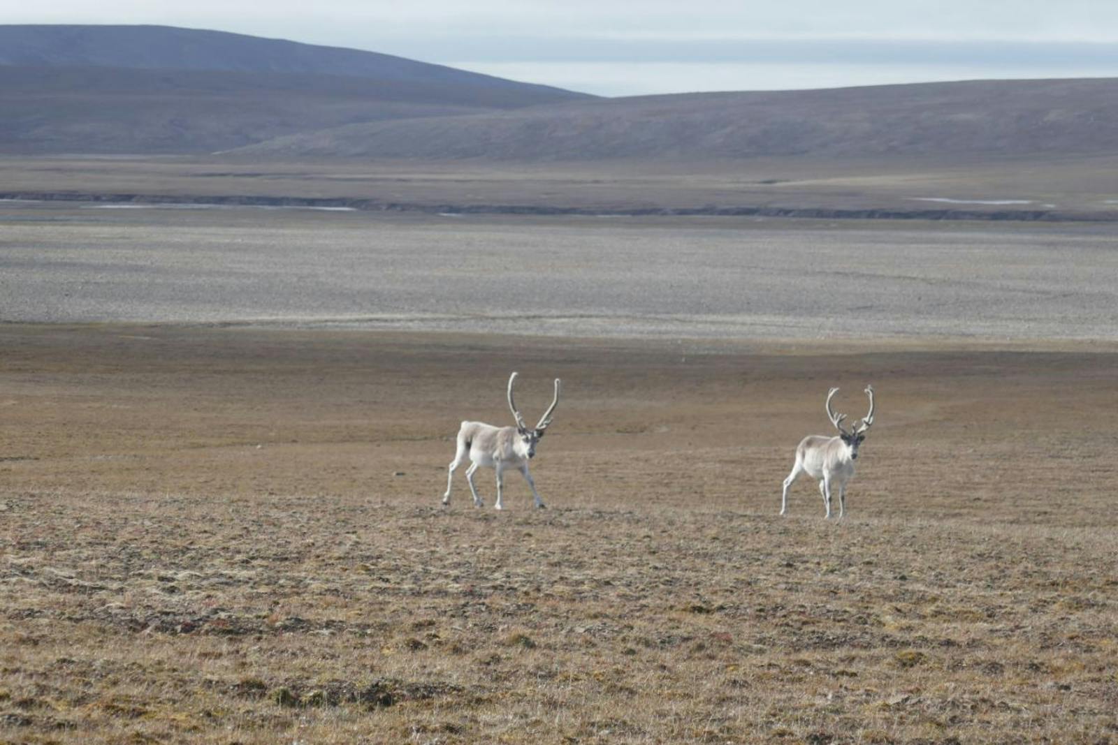
is%20a%20subspecies%20of%20caribou%20found%20in%20the%20High%20Arctic%20islands%20of%20Nunavut%20and%20the%20Northwest%20Territories%20in%20Canada.%20Image%20credit%20Wirestock%20_%20Dreamstime.jpg "The peary caribou (Rangifer arcticus pearyi)is a subspecies of caribou found in the High Arctic islands of Nunavut and the Northwest Territories in Canada.")
The Peary caribou (Rangifer arcticus pearyi) is the flagship species of the Canadian High Arctic Tundra ecoregion. Image credit: ©Wirestock | Dreamstime
This vast ecoregion borders the Canadian Middle Arctic Tundra to the south and the Davis Highlands Tundra on the eastern edge of Baffin Island. The western portion of the Canadian High Arctic Tundra is predominantly flat, underlain by sedimentary rocks from the Paleozoic and Mesozoic eras. Rugged mountains, reaching elevations of up to 2,500 meters, are found along the northern and western coasts of Ellesmere and Axel Heiberg Islands.
Moving eastward and southward, much of the ecoregion is composed of lowland plains blanketed by glacial deposits, though significant ridges are present on the Parry Island Plateau. East of Prince of Wales and Somerset Islands, the landscape transitions to plateaus and rocky hills formed from Precambrian granitic bedrock.
The northern half of the ecoregion’s ocean remains ice-covered for most or all of the year. However, with global warming, the extent and duration of open-water conditions are increasing and shifting further north. Despite its ecological importance, only 8% of this ecoregion is under formal protection, although an additional 69% of its habitat remains intact outside protected areas.
Notable protected areas include Qausuittuq National Park on Bathurst Island and Quttinirpaaq National Park, located at the northeastern tip of Ellesmere Island. In Inuktitut, Quttinirpaaq translates to "top of the world."
.jpg "Arctic fox (Alopex lagopus) in the snow. Photo | Dreamstime_34412245")
Arctic fox (Alopex lagopus) in the snow. Photo | Dreamstime_34412245
The climate of this ecoregion is classified as high Arctic, marked by extremely cold and dry conditions. Mean summer temperatures in the northern part of the ecoregion are just -1.5ºC, while in the southern areas, they can reach up to 2ºC. Average winter temperatures range from -32ºC in the north to -23ºC in the south. Permafrost is continuous and extends several hundred meters deep.
Annual precipitation averages only 100–200 mm across most of the region but increases to 400 mm in the higher elevations of Baffin Island. The northern areas of this ecoregion experience the lowest precipitation levels in Canada, with annual totals as low as 50 mm.
Due to the extreme cold and limited moisture, the northern portion of the ecoregion supports sparse vegetation, consisting of cold-hardy lichens, mosses, and a few vascular plants, primarily sedges like cottongrass. Arctic willow and species of mountain avens grow at lower elevations, alongside low-growing herbs such as purple saxifrage, Arctic poppy, and bog sedges. In the relatively milder southeastern part of the ecoregion, vegetation is similar but often more continuous, with wet areas supporting denser growths of wood rush, wire rush, and various saxifrages.

Polar bear mother and baby cub. Image credit: Wildlife Exchange
Characteristic mammals in this ecoregion include polar bears (found in coastal areas), the Arctic wolf subspecies, musk ox, barren-ground caribou, and Arctic hare. Among these, the caribou is represented by the endangered Peary caribou, the smallest subspecies of caribou in North America, which defies Bergmann’s Rule—a generalization that predicts body size within species of mammals and birds increases with latitude.
The Peary caribou population has declined dramatically, from over 40,000 individuals in 1961 to approximately 700 in 2009. This sharp decrease is attributed to an increasing number of days with temperatures above freezing, leading to ice layers in the snowpack that impede foraging.
Marine mammals in the region include walruses, several species of seals and whales, and narwhals in southern areas. Notable bird species include the king eider, snow goose, rock ptarmigan, northern fulmar, various plovers, sandpipers, seabirds, hoary redpoll, and snow bunting. In the southern parts of the ecoregion, species such as the gyrfalcon, snowy owl, and various jaegers are prominent. Breeding populations of Ross’s gulls and ivory gulls are also found within this ecoregion.
Despite the largely intact habitat, the poor protection status makes this ecoregion a high priority for the expansion of protected areas. While its extreme climate and remoteness have shielded it from extensive development, oil and gas exploitation has occurred and is likely to increase in the future.
Priority conservation actions for the next decade:
- Greatly expand the network of protected areas across the ecoregion.
- Prohibit incompatible uses, including oil production, within designated protected areas.
- Protect vulnerable species from over-harvest and develop and implement recovery plans for the most imperiled species, such as Peary caribou.
-
-
1. Ricketts, T.H. et al. 1999. Terrestrial Ecoregions of North America: A Conservation Assessment. Island Press, Washington, D.C.
2. Ecological Stratification Working Group. 1995. A National Ecological Framework for Canada. Environment Canada and other agencies, Ottawa.
3. Qausuittuq National Park. https://en.wikipedia.org/wiki/Qausuittuq_National_Park -
Cite this page: Canadian High Arctic Tundra. Ecoregion Snapshots: Descriptive Abstracts of the Terrestrial Ecoregions of the World, 2021. Developed by One Earth and RESOLVE. https://www.oneearth.org/ecoregions/canadian-high-arctic-tundra/
-

Subscribe to receive monthly updates on climate solutions, environmental heroes, and the profound beauty and wonder of our shared planet Earth.
