
Bioregions 2020

This information has been updated. Please see Bioregions 2023.
If Nature were to draw a map of the world what would it look like? We’ve grown accustomed to seeing the world divided into countries, but there is another way to see, and better understand, the planet we call home. One Earth presents a novel biogeographical framework called Bioregions 2020, which builds upon 844 terrestrial ecoregion divisions (Dinerstein et al. 2017) to delineate 185 discrete bioregions organized within the world's major biogeographical realms.
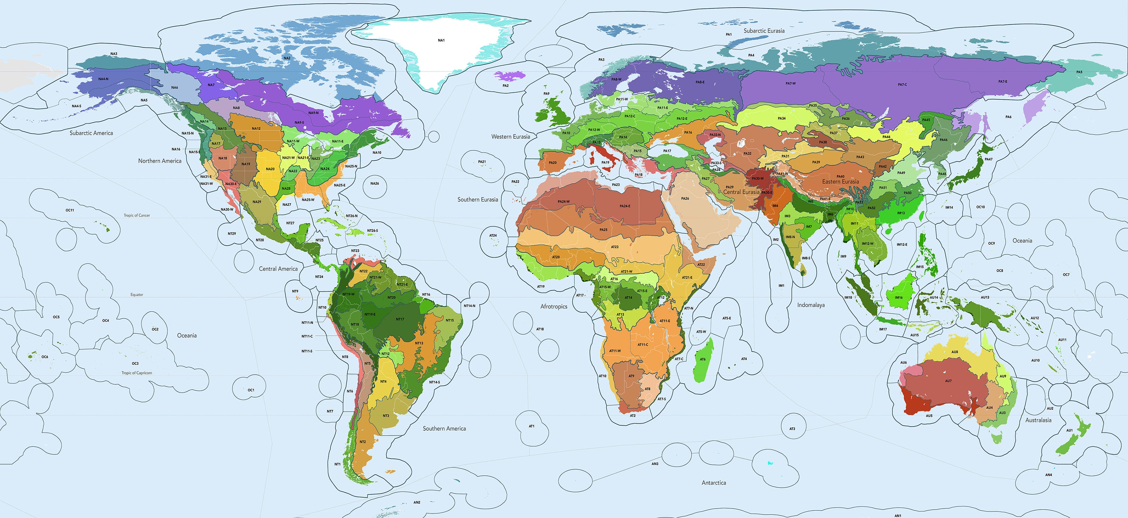
Bioregions 2020: a new map of the Earth created by intersecting biomes with large-scale geological structures to delineate 185 discrete bioregions. Download Map (6 MB). Credit: Karl Burkart, One Earth
Two years in development, with input from an array of field scientists, conservation experts, and geographers, Bioregions 2020 provides a framework to support scientific research and grantmaking efforts across a group of related ecosystems. It can also be useful as an educational tool, helping people better understand the underlying ecological fabric of life that surrounds them.
Why Bioregions?
While referenced frequently in scientific literature for conservation planning, the terrestrial ecoregions are often too small and too numerous to be used for country-level or large-scale regional planning efforts. In many cases the spatial configuration of one ecoregion is embedded within another and cannot be considered apart. One clear example of this is the U.S. Central Rocky Mountain Forests, which are tightly interlinked with the Montana Valley Grasslands. In other cases, groups of similar ecoregions that are adjacent to each other, for example the three northern grassland ecoregions just to the east of the Rockies, share similar attributes and thus from a conservation perspective could be considered in tandem.
One major benefit of this bioregional framework is that it allows for the integration of all three types of ecoregions – terrestrial, freshwater, and marine -- into a cohesive system. The portion of rivers, streams, lakes, and ponds that flow through a terrestrial ecoregion are included in the bioregion, and in some cases a watershed’s footprint influences the grouping of overlapping terrestrial ecoregions. Similarly, bioregions with coastal edges are extended to the corresponding country’s Exclusive Economic Zone (EEZ) boundaries. While EEZs are administrative, not biological, boundaries they do provide an ecosystem constraint as most fishing and industrial activities occur within the EEZs. “Marine Ecoregions of the World” (Spalding et al. 2007) is referenced in Bioregions 2020, and in some cases informs the clustering of terrestrial ecoregions.
The 185 bioregions are organized by the world’s major biogeographical realms, the broadest division of the Earth's land surface within which groupings of organisms share a common evolutionary history -- Nearctic, Neotropic, Palearctic, Afrotropic, Indomalayan, Australasian, Oceanian, and Antarctic. The realms roughly correspond to the major continents of the Earth but are further subdivided to coincide with familiar climatic zones. For example, the Neotropical realm is divided into Central America and Southern America. These realm divisions – 14 in total -- provide the overarching content framework for the One Earth website and its Project Marketplace.
Bioregions cannot cross a realm line, so each realm contains a finite number of bioregions, which can be grouped into subrealms:
- Subarctic America (north Nearctic): 9 bioregions, 4 subrealms
- Northern America (greater Nearctic): 22 bioregions, 6 subrealms
- Central America (north Neotropic): 6 bioregions, 2 subrealms
- Southern America (greater Neotropic): 23 bioregions, 5 subrealms
- Subarctic Eurasia (north Palearctic): 8 bioregions, 4 subrealms
- Western Eurasia (west Palearctic, aka W. Europe): 13 bioregions, 5 subrealms
- Central Eurasia (central Palearctic, aka C.Asia): 9 bioregions, 4 subrealms
- Eastern Eurasia (east Palearctic, aka E. Asia): 18 bioregions, 7 subrealms
- Southern Eurasia (south Palearctic, aka MENA): 5 bioregions, 2 subrealms
- Afrotropics (aka Sub-Saharan Africa): 24 bioregions, 5 subrealms
- Indomalaya (aka South & Southeast Asia): 18 bioregions, 3 subrealms
- Australasia: 15 bioregions, 3 subrealms
- Oceania: 11 bioregions (not subdivided)
- Antarctica: 4 bioregions (not subdivided)
Bioregions Development
What is a bioregion? A bioregion is a geographical area defined not by political boundaries but by ecological systems. It is smaller in scale than a biogeographical realm, but larger than an ecoregion or an ecosystem. On land, the most widely held bioregional framework is the biome or “ecozone” -- a large community of plants and animals adapted to a specific climate found over a range of continents. There are 14 widely held biome types, mapped below with an overlay of the 185 bioregions:
- Deserts & Xeric Shrublands (rust)
- Mountain Grasslands & Shrublands (beige)
- Temperate Grasslands, Savannas & Shrublands (yellow)
- Tropical & Subtropical Grasslands, Savannas & Shrublands (orange)
- Flooded Grasslands & Savannas (light blue)
- Mangroves (pink)
- Mediterranean Forests, Woodlands & Scrub (red)
- Temperate Broadleaf & Mixed Forests (dark green)
- Temperate Conifer Forests (grey-green)
- Tropical & Subtropical Coniferous Forests (light green)
- Tropical & Subtropical Dry Broadleaf Forests (olive green)
- Tropical & Subtropical Moist Broadleaf Forests (bright green)
- Boreal Forests/Taiga (medium blue)
- Tundra (teal)
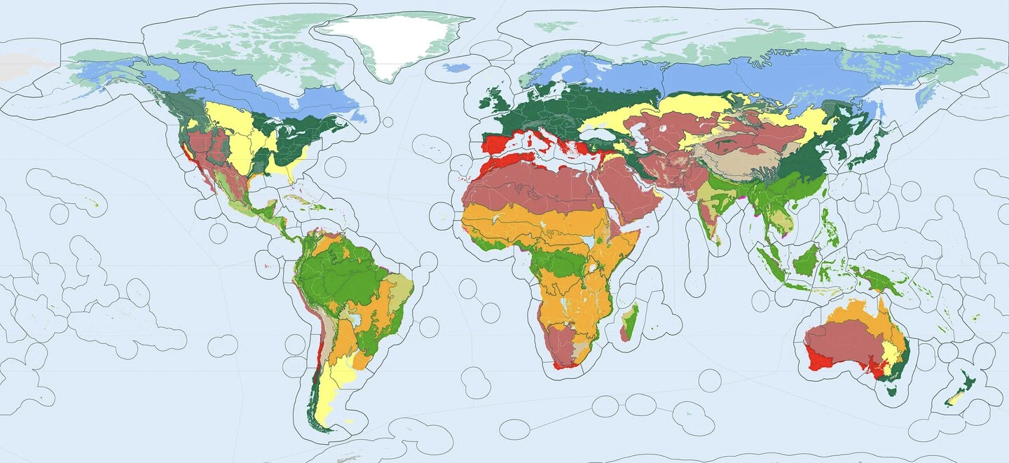
The Earth's 14 major biomes, which include 6 subtypes of the generic 'forest' biome: boreal, temperate broadleaf, temperate conifer, tropical moist broadleaf, tropical dry broadleaf, tropical conifer. The biomes provide the guiding framework for the development of the 185 bioregions. Download Map (6 MB). Credit: Karl Burkart, One Earth
Biomes provide the organizing principle used to group ecoregions into 185 discrete bioregions. Conceptually, bioregions are major subdivisions of the Earth’s biomes, formed by intersecting biome areas with large-scale geological structures -- such as mountain ranges, plains, plateaus, and basins -- or using common climatological divisions. The bioregions include adjoining freshwater and marine areas, and in some ways could be thought of as “nature’s countries” with an average land area of approximately 800,000 km2.
A consistent rule set was applied in the creation of the bioregions across all realms, and specific scientific publications pertaining to each realm were referenced in order to align the bioregions as closely as possible with commonly held ecological divisions by continent. The top-level rules used in the development of the 185 bioregions across all realms are as follows:
- Bioregions are subdivisions of the major biomes, defined most commonly by large-scale geological structures or familiar climatological zones. An example of this is the great plains of the Midwest U.S. divided into three bioregions -- north, south, and central.
- Bioregions must be contained inside one of the 14 major biogeographical realms. A bioregion cannot cross over from one realm to another.
- Bioregions consist predominantly of one biome type. In some cases, ecoregions belonging to another biome are included when those ecoregions are embedded or closely linked to the ecoregions in the adjoining biome. An example of this is the Guianan savanna, which cannot be separated from the adjacent Guianan forests.
- Ecoregions are the building blocks of each bioregion. An ecoregion is never split between two bioregions with the exception of mangroves, which often span across multiple bioregions.
- Bioregions include the marine areas beyond the coastline. These are demarcated using the EEZ boundary lines, as these waters are often heavily fished, or experience impacts from activity on adjacent land areas. In some cases, marine provinces (Spalding et al. 2007) are used to articulate a bioregion.
- Bioregional divisions are commensurate in scale to countries, with an average area of approximately 800,000 km2. Bioregions vary in scale, ranging from roughly 100,000 km2 to 4 million km2 (not including small island states or Siberia, which has three subdivisions but is considered one very large bioregion).
The Subrealms
Bioregions can be grouped into subrealms -- intermediary divisions of the major realms that cluster bioregions into a more familiar geographical taxonomy. For example, the "Amazonia" subrealm is defined as a cluster of 5 tropical forest bioregions roughly coinciding with the Amazon River basin. There are 52 subrealms identified in the One Earth Bioregions 2020 framework. Colors are generated from the dominant bioregions contained within each subrealm:
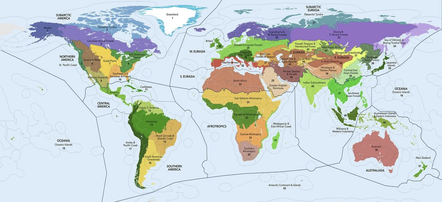
The 52 subrealms of the Bioregions 2020 framework. Download High Resolution Map. Download Map (6 MB). Credit: Karl Burkart, One Earth
- Subarctic America -- Greenland (cyan), Canadian Tundra (blue), Alaska (indigo), Canadian Boreal Forests (purple)
- Northern America -- North Pacific Coast (blue-green), American West (brown), Great Plains (gold), Northeast American Forests (green), Southeast U.S. Savannas & Forests (orange), Mexican Drylands (olive)
- Central America -- Central America (light green), Caribbean (green)
- Southern America -- Upper South America (pale green), Amazonia (deep green), Brazil Cerrado & Atlantic Coast (tan), South American Grasslands (yellow), Andes Mountains & Pacific Coast (dark green)
- Oceania -- Oceanic Islands (green)
- Afrotropics -- Madagascar & East African Coast (bright green), Southern Afrotropics (rust), Sub-Equatorial Afrotropics (orange), Equatorial Afrotropics (emerald green), Sub-Saharan Afrotropics (tan)
- South Eurasia -- North Africa (red-orange), Greater Arabian Peninsula (beige)
- West Eurasia -- Mediterranean (red), Black Sea Forests & Steppe (gold), European Mountain Forests (dark green), Greater European Forests (green), British Isles (emerald green)
- Subarctic Eurasia -- Palearctic Tundra (teal), Scandinavia & Western Boreal Forests (purple), Siberia & Eastern Boreal Forests (plum), Sea of Okhotsk & Bering Tundra/Taiga (lavender)
- East Eurasia -- Japanese Islands (dark green), Northeast Asian Forests (grey-green), Mongolian Grasslands (yellow), Central East Asian Forests (pale green), Himalayas & Tibetan Plateau (tan), East Asian Deserts (red-brown), Altai-Sayan Mountains (olive green)
- Central Eurasia -- Kazakh Steppes & Hemiboreal Forests (chartreuse), Caspian Sea & Central Asian Deserts (brown), Tien Shan Mountains (tan), Persian Deserts & Forests (dark red)
- Indomalaya -- Indian Subcontinent (light green), Southeast Asian Forests (emerald green), Malaysia & Western Indonesia (dark green)
- Australasia -- Australasian Islands & Eastern Indonesia (olive green), Australia (red), New Zealand (green)
- Antarctica -- Antarctic Continent & Islands (not shown)
Click on each of the links above to learn more details about bioregion groupings within the 52 subrealms.

Subscribe to receive monthly updates on climate solutions, environmental heroes, and the profound beauty and wonder of our shared planet Earth.